Space debris currently poses a great threat to the future of space operations, accessibility, and exploration. Due to our increased dependency on satellites, if left unaddressed, space debris can cause damage to assets in space and to life on Earth. Detecting, cataloguing, and predicting Resident Space Objects (RSO) is the first step towards solving the problem of orbital debris and having a sustainable and accessible near-Earth orbit. Current technological capabilities allow for the tracking of objects larger than 10 cm. However, the current resolution of ground-based space surveillance systems leaves 96 per cent of the approximately 1 million lethal space objects untracked, and even for the tracked 4 per cent, complex metrics (object profile and error statistics) are unavailable, rendering the tracking data operationally irrelevant. Digantara is developing a two-pronged system to address the difficulties of space operations and situational awareness through the Space Mission Assurance Platform, aka Space-MAP. Space-MAP will serve as a one-stop solution for all space operations, with products offered through a data feedback loop using multi-modal data sets. This platform will be as powerful and sophisticated as Google Maps, serving as a foundational layer for space operations and astrodynamics research. Through Space-MAP, Digantara can track objects at 10x higher resolution in daylight and in eclipse, increasing the ability to track 20x more objects.
Benefits:
One-stop portal for all space operations
Common operational picture through data fusion using multimodal data sets
Capability to track RSOs at 10x higher resolution in both daylight and eclipse
Near-real-time in-situ monitoring of space weather
Next-generation satellite navigation from LEO for autonomous vehicles and other modern applications
Nearly every form of modern transportation now relies on the free GPS (GNSS) services as provided by major governments, and as we enter the age of autonomy this reliance is getting stronger. However many navigation services are based on an architecture that was designed nearly a half-century ago, and are failing to meet the requirements needed for modern systems to operate safely when it comes to accuracy, security, and resilience. Xona is leveraging the advacements of the new space era to develop Pulsar: a constellation of small but powerful navigation satellites in low Earth orbit, more than 20x closer to Earth than GPS. Pulsar will provide secure navigation services that are more than 100x stronger and 10x more accurate than GPS, enabling reliable sub-10cm level positioning anywhere on Earth. Xona’s patent-pending distributed atomic-clock architecture is at the core of Pulsar which allows high-performance services to be provided from small satellites without the need for large atomic clocks onboard.
Benefits:
Sub 10-cm accuracy without any external corrections
Over 100x more powerful and resistant to interference than current GNSS
Secure service protected by encryption and authentication to support safety-critical applications
LEO small sat architecture allows for affordable servies globally
Massive and broad market potential – over 6 billion devices already using GNSS today
With a rapidly changing climate and the emergence of readily available satellite imagery, there exists both the need and opportunity to switch over from an interval-based to a needs-based approach for the maintenance of infrastructure assets – HACARUS’s innovation helps enable this shift. Current solutions for AI-based image analysis typically require large, well-defined data sets for creating AI models. In addition, these often fail when applied to real-world scenarios due to sensitivity over discrepancies between data used for training and observed data. HACARUS’s solution is powered by its proprietary sparse modelling-based AI engine, which is uniquely adept at overcoming these challenges – the core algorithms allow for the creation of highly accurate AI models from small data sets, which means it is also able to quickly add new objects of interest. This allows for an AI system that is able to adapt to changes over time, and that can provide an instant bird’s eye view of an asset’s current health. The human-centric design, including smart features such as heat maps and bounding boxes, provides operators with actionable insights for smarter maintenance operations.
Benefits:
Enables a shift from interval-based to needs-based maintenance
Provides instant insights at a glance concerning object location & change over time
Allows for maintenance and surveillance work to be performed remotely
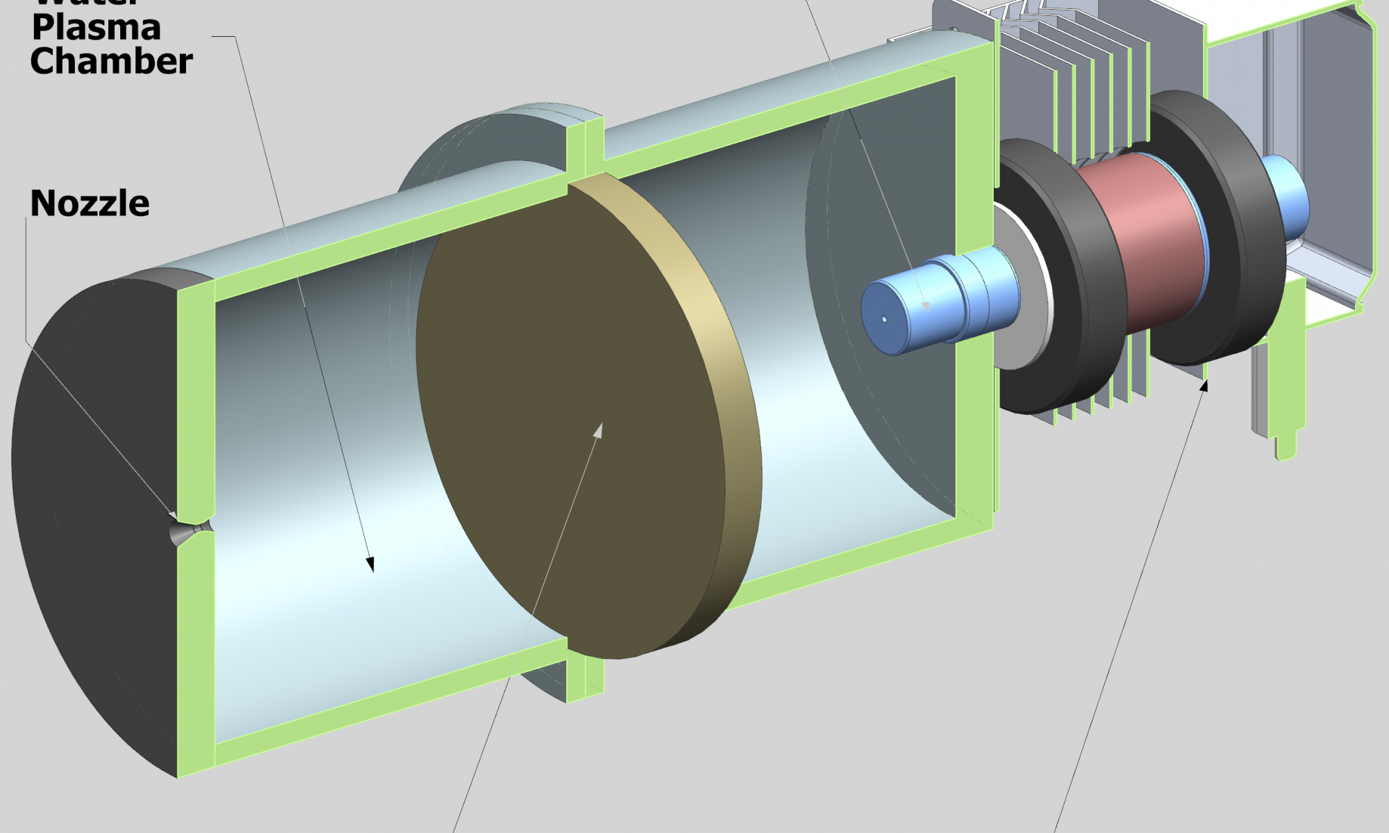
Sustainable spacecraft propulsion by water as the expellant mass
Water is abundant in the solar system. It can be found on the Moon, Mars, the icy moons of Jupiter and on smaller celestial bodies such as asteroids. Considering that it is a must for long-term human presence in space and that it can be used for many purposes, such as radiation shielding or energy storage, it is also conceivable to use it as a propellant or expellant in a propulsion system. It has ideal properties as an expellant: high density, a liquid state at low energy conditions, it is unharmful and simple to handle. Heating the water to plasma state and expanding it in a nozzle forms a highly effective, yet simple, type of electric propulsion system. The high achievable temperature enables a significant saving in propellant mass over chemical in-orbit propulsion systems. The author’s proposal is to make use of advancements in electronics and manufacturing to push this known concept to a new stage within a joint research project. Earlier laboratory demonstrators used bulky and inflexible magnetrons with a high voltage input. A new type of solid-state microwave generator enables a lightweight design and excellent tunability at a low voltage, yet with a high power level. Contactless, low-wear heating of a green expellant such as water open up an excellent opportunity within propulsion technology. The simplicity of such a propellant also reduces the risk assessment of the system in general and on rideshare missions.
Benefits:
Water as a cheap, green expellant
Simple, long-term reliability due to contactless heating
Uncomplicated approval process due to high safety
Greater payload than for chemical propulsion systems
Versatile approach for cloudless optical satellite data
In Earth observation, clouds and shadows are the most limiting factors for consistent and up-to-date imagery. While optical satellite data can be retrieved daily, actionable insights are much rarer. To overcome this lack of cloudless data, large identical satellite constellations are required. However, this only improves one’s chance of actionable insights while ignoring the root cause. Less than perfect data is still not utilised in this process and is often even difficult to identify. ClearSky Vision addresses these problems by integrating data from various missions (Sentinel-1, Sentinel-2, Landsat 8, and more) while using a novel neural network to predict urban and landscape changes underneath the cloud cover. This data fusion process is repeatable on different satellites. This allows for more consistent and frequent retrieval of multi-spectral cloudless satellite imagery and indices that are crucial to improved time-series analysis and anomaly detection. Satellites with different instruments and revisit speeds can be utilised in synergy, thereby combining the best features of different satellites.
Benefits:
The most up-to-date cloudless optical imagery (updated daily)
Enables utilisation of multiple different satellites for the same application
Enables affordable continuous monitoring for large areas
Highly versatile and efficient data fusion process
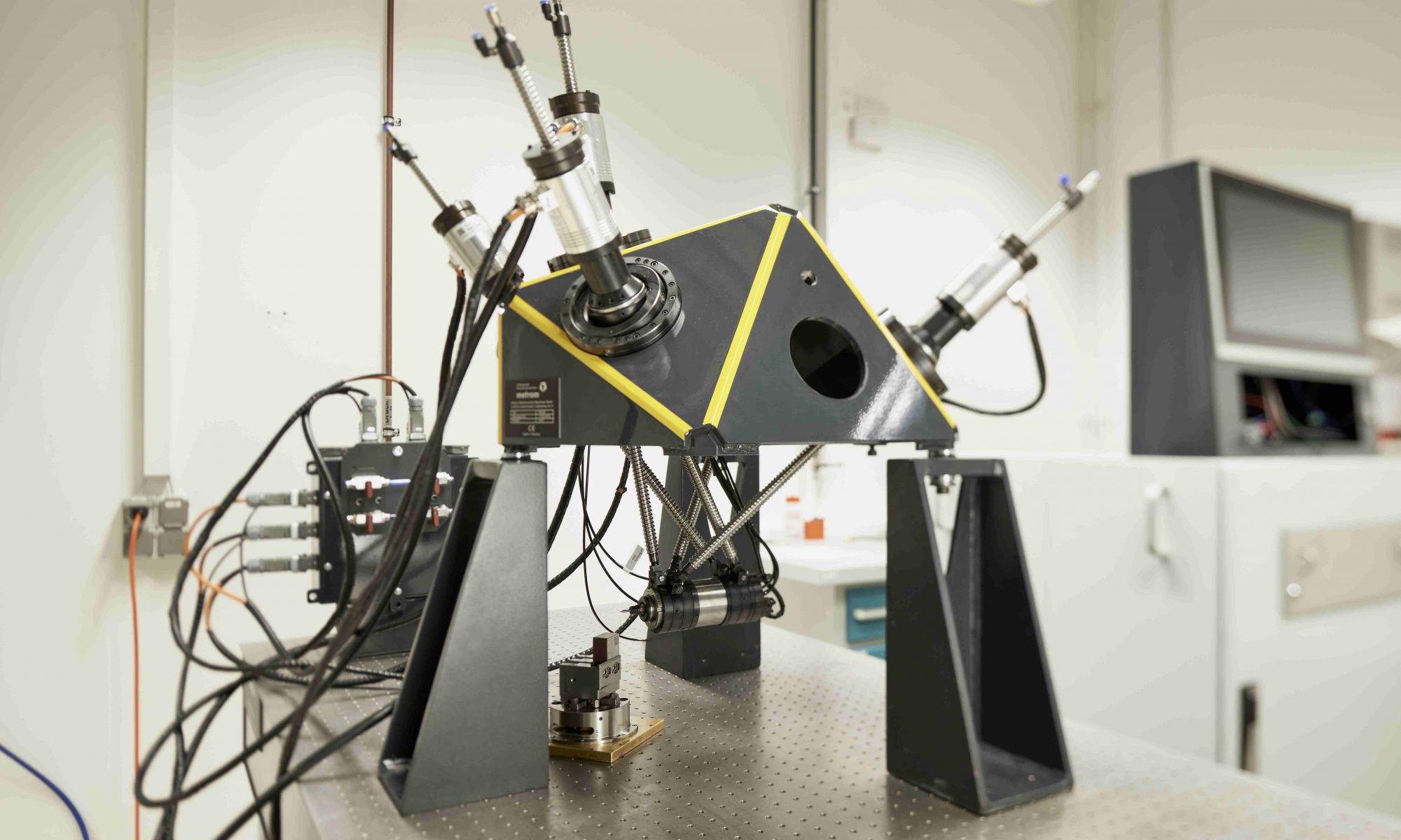
Small intelligent system for space independence (SISSI)
It will be necessary to establish local production capabilities in space in the near future. The transport costs and time until components are available are the most important factors here, which make it essential to manufacture and repair on site. The conventional production capabilities available up to now on Earth are heavy, cannot be transported, and require mechanical precision in the machine structure to allow for accuracy on the workpiece. Robots used for processing are not precise enough and consist of various individual components. The solution here is to develop and manufacture a miniaturised processing system based on parallel kinematics. The modular basic structure and the inherent features of the functionality demonstrated on Earth are redesigned, manufactured in a miniaturised form, and put into operation. This is what SISSI was made for. A small processing system, which can adapt to the environmental conditions and always creates the optimal result with the lowest possible use of resources.
Benefits:
Mechanically simple structure with repeated components
μ-level precision thanks to self-calibration
Processing in unfavourable conditions thanks to dust protection and temperature compensation
No limit on processing by replacing the technological tools
High degree of stiffness due to special frame shape
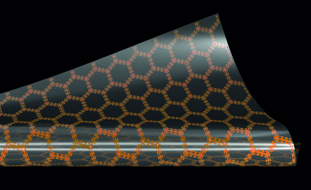
TOMOPLEX – A sensor film to monitor structures during flight and under a load
Only reusability ensures cost-effectiveness in order to be able to operate the space sector in line with “New Space”. However, the possible saving in costs is limited by maintenance requirements. Some faults also only occur under a load, but remain hidden during inspections without a load. One example of this is break lines, which fit together perfectly in an unloaded state. A comprehensive installation of measuring probes to monitor structures during flight is not currently feasible, as the conventional measuring technology required for this is too large and heavy. The problem of needing to monitor structures in real time has now been resolved by creating a version of the sensor as a sensor film that can be applied to the surfaces of the structures undergoing monitoring. It is possible to use alternative measuring procedures and, in particular, electric impedance tomography (EIT) here, which has been uncommon in the aerospace sector up to now. The sensor film acts as the circuit carrier for a wireless sensor network. The sensor film is space-saving and flexible, and can also be used in hard-to-reach areas.
Benefits:
Continuous real-time monitoring under a load during flight
Increase in the likelihood of reusability
Reduced costs due to optimised maintenance with the aid of innovative analysis data
PANTOhealth – Real-time infrastructure monitoring and maintenance 4.0
A total of 3.7 million minutes, or 2,570 days, was the delay of ICE and Intercity trains in Germany for 2018 according to data from Deutsche Bahn and the German Bundestag. Infrastructure damage to railway lines is one of the main reasons for this. This is caused, in particular, by the fact that maintenance work is often carried out either too early or too late. PANTOhealth GbR aims to disrupt the maintenance plan of the mechanical infrastructures of the railway industry through condition monitoring and predictive maintenance. Its first service focuses on the maintenance of pantographs and overhead lines. Extensive data is collected via the PANTOsystem, which consists of simulation software, patented hardware for data acquisition, cameras and various sensors. Big data analysis can predict the appropriate time and exact geographic location of necessary maintenance work. This service will significantly reduce maintenance costs, while also increasing the lifetime of the pantograph and overhead line system.
Benefits:
Predictive Maintenance 4.0: Displaying of the most effective maintenance plan to reduce costs and prevent the most common causes of damage
Reduction of maintenance costs in the railway sector by up to EUR 6.6 billion annually
Considerable improvement in the punctuality of trains
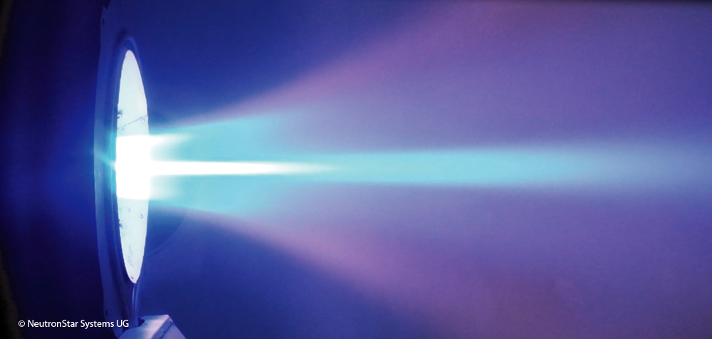
NeutronStar Systems UG is developing a disruptive electric propulsion technology that can reduce mission costs for satellite operators by tens of millions of euros, through cheaper propellant and more efficient operation. It calls the solution SUPREME (SUPerconductor-Based Readiness Enhanced Magnetoplasmadynamic Electric Propulsion). It is based on widely-research appliedfield magnetoplasmadynamic (AF-MPD) thrusters and industrially mature high-temperature superconductors. SUPREME offers the benefits of AF-MPD technology, namely excellent scalability, a wide operational range, and the ability to use alternative propellants, which are more sustainable and considerably cheaper than existing options. The use of superconductors greatly reduces the mass, volume and power consumption of the propulsion system, while simultaneously enabling longer lifetimes and greater performance.
Benefits:
Compact and efficient propulsion system with a wide range of applications
Scalability across a wide range of power classes (750W – 1000kW)
Uses propellants which are 100 times cheaper than xenon
Greater operational flexibility for orbital transfers, reducing fuel consumption
GNSS common-view – Time and frequency synchronisation for industry
Time synchronisation is a basic requirement for operating important infrastructures in almost all industrial sectors worldwide, such as the energy, telecommunications, transport and financial sectors. The high demands on the accuracy of time measurement, which is currently in the single-digit nanosecond range, are an essential driver of technology and innovation to take time measurement into ever new dimensions. Time synchronisation is traditionally achieved via cable protocols with their own network timing. The use of such dedicated networks is not always possible for financial or logistical reasons, such as for systems operating on different continents (finance), in densely populated urban areas (5G or IoT) or for highly decentralised systems (blockchain). Melior Systems GmbH is working on a cost-effective, global system solution for highly accurate time synchronisation based on the atomic clocks of navigation satellites (GNSS) in combination with exact time comparisons using what is known as the common-view method. The system solution is offered to infrastructure operators and other customers as a software licence in conjunction with support services.
Benefits:
Time and frequency synchronisation based on GNSS with 1-digit nanosecond accuracy
Cost-effective deployment independent of the link distance to synchronise
Reduced costs of infrastructure in urban areas and improved indoor GNSS reception

 orbiting earth")