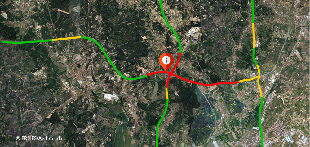
ERMES – Extensive road monitoring and early-warning system
Slope stability and ground subsidence along roads and railway tracks are currently monitored using inclinometers and land surveying. These measures lead to substantial logistical challenges and increased costs. THEIA has developed ERMES (Extensive Road Monitoring Early Warning System) to perform large-scale road infrastructure monitoring through satellite data. The system uses multiple advanced remote sensing methodologies to track ground deformation and monitor slope stability and ground subsidence throughout road and railway networks. Using high-frequency remote sensing data, ERMES can determine the speed of deformation and set up an early-warning system for structural health monitoring. This enables efficient, preventive maintenance strategies to be implemented and measures to be optimised to minimise risk.
Benefits:
Enables regular monitoring of large infrastructure using satellite data
Optimisation of maintenance costs and operations for road and rail infrastructure
Reduction of critical outages and increase in security
PANTOhealth – Real-time infrastructure monitoring and maintenance 4.0
A total of 3.7 million minutes, or 2,570 days, was the delay of ICE and Intercity trains in Germany for 2018 according to data from Deutsche Bahn and the German Bundestag. Infrastructure damage to railway lines is one of the main reasons for this. This is caused, in particular, by the fact that maintenance work is often carried out either too early or too late. PANTOhealth GbR aims to disrupt the maintenance plan of the mechanical infrastructures of the railway industry through condition monitoring and predictive maintenance. Its first service focuses on the maintenance of pantographs and overhead lines. Extensive data is collected via the PANTOsystem, which consists of simulation software, patented hardware for data acquisition, cameras and various sensors. Big data analysis can predict the appropriate time and exact geographic location of necessary maintenance work. This service will significantly reduce maintenance costs, while also increasing the lifetime of the pantograph and overhead line system.
Benefits:
Predictive Maintenance 4.0: Displaying of the most effective maintenance plan to reduce costs and prevent the most common causes of damage
Reduction of maintenance costs in the railway sector by up to EUR 6.6 billion annually
Considerable improvement in the punctuality of trains
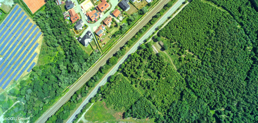
Heavy storms are increasingly causing millions of euros of damage to tracks and systems as well as train failures and delays. OCELL GmbH specialises in AI-driven analysis of aerial photography and geodata in order to collect vegetation data with an accuracy of individual trees and categorise the data according to risk classes. Data collection is carried out by the company’s own decentralised partner network of professional ultralight aircraft pilots. In order to ensure a constant ground resolution, the flight altitude relative to the ground must remain constant. This is achieved with the help of high-quality radar satellite data and navigation satellites. OCELL GmbH offers data collection and high-precision data interpretation as a comprehensive service for forestry and infrastructure managers (train lines, power lines, oil and gas pipelines). On the basis of the resulting findings, e.g. trees that pose a risk can be cut in a targeted manner as a preventative measure.
Benefits:
Prevention of delays, image damage and property damage amounting to millions of euros
Large-scale, high-resolution data collection with ultralight aircraft and the company’s own pilot network
Precise data on individual tree information (tree species, condition, height, drop distance)
Future robotic and manned Mars missions require high-resolution images of large sections of the planet. The current geographic coverage is achieved either from great height (400 km), or by rovers directly on the surface. Mars Torus is a unique craft, able to produce high-definition images at a height of 2 km while navigating widely over the planet’s surface. Thanks to its structure and a contained vacuum, Torus achieves lift in the thin Martian atmosphere. It thus has a very low energy demand. The energy required for forward momentum and further functions can be generated by solar panels. Mars Torus will have the mobility to relocate in the atmosphere to predefined locations, helping to map locations of interest and search for traces of water and methane. To allow Mars Torus to navigate precisely and communicate with Earth, it will have its own supporting satellite navigation system via a network of pre-positioned cubesats.
Benefits:
High-definition images of the Mars surface
Autonomous waypoint navigation around Mars
Chemical sampling of the Mars atmosphere
Reduction in the risk to future robotic and human missions
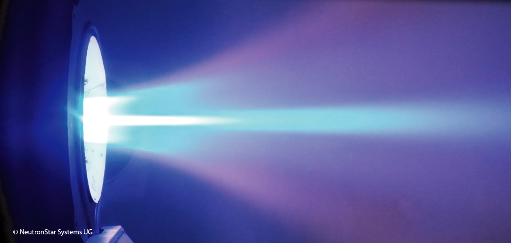
NeutronStar Systems UG is developing a disruptive electric propulsion technology that can reduce mission costs for satellite operators by tens of millions of euros, through cheaper propellant and more efficient operation. It calls the solution SUPREME (SUPerconductor-Based Readiness Enhanced Magnetoplasmadynamic Electric Propulsion). It is based on widely-research appliedfield magnetoplasmadynamic (AF-MPD) thrusters and industrially mature high-temperature superconductors. SUPREME offers the benefits of AF-MPD technology, namely excellent scalability, a wide operational range, and the ability to use alternative propellants, which are more sustainable and considerably cheaper than existing options. The use of superconductors greatly reduces the mass, volume and power consumption of the propulsion system, while simultaneously enabling longer lifetimes and greater performance.
Benefits:
Compact and efficient propulsion system with a wide range of applications
Scalability across a wide range of power classes (750W – 1000kW)
Uses propellants which are 100 times cheaper than xenon
Greater operational flexibility for orbital transfers, reducing fuel consumption
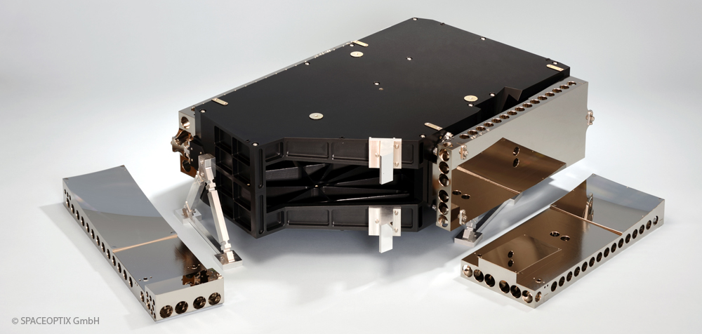
The rapidly increasing number of commercial satellites, with some 25,000 small satellites* for Earth observation and communication services alone in the next few years, poses a completely new scaling problem for component and subsystem suppliers. In addition, Earth observation as well as laser and quantum communication increasingly require high-quality optical subsystems with nanometre precision, such as telescopes, spectrometers or pointing mirrors, to enable high-resolution observation data or increased transmission speeds. SPACEOPTIX GmbH develops and manufactures high-quality opto-mechanical components and systems made of metallic substrates. Compared to alternative materials such as glass or ceramics, the metal optical mirrors and mirror systems offer significantly reduced manufacturing and assembly costs and, by using free-form optical system designs, an excellent ratio between optical imaging quality, mass and volume. As a Fraunhofer IOF spin-off, the aim of SPACEOPTIX GmbH is the technology transfer of 20 years of applied research in the field of metal optics to industrial standards.
* www.researchandmarkets.com, 2019, Small Satellite Market Size, Growth and Industry Forecast, 2026
Benefits:
Reduced manufacturing costs compared to optics made of alternative materials
Efficient realisation of compact freeform optical system designs (miniaturisation, increase of image quality)
Integration of mechanical functions into the optical mirror component and thus application of simplified mounting principles (“snap-in” assembly)
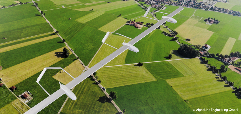
The civil UAV market with a worldwide market volume of USD 6.56 billion in 2018 is expected to grow to USD 43 billion by 2024*. Market growth in the coming years will be driven by the large number of new commercial applications, in particular by the use of unmanned stratospheric flight systems for telecommunications and Earth observation services. For perennial operation at high altitudes, these aircraft require an extremely large wingspan with the lowest possible structural weight. When flying in the troposphere, conventional aircraft configurations face a particular risk that greater turbulences could lead to cracks and fractures in the aircraft structure. The Berlin-based company AlphaLink Engineering GmbH is currently developing a compound aircraft that can solve this structural-mechanical lightweight construction dilemma by connecting multiple aircraft modules at their wingtips through mechanical joints. After intensive research at Technische Universität Berlin, the patented technology is now being tested by AlphaLink in the form of test vehicles and flight trials. The compound aircraft is the first electrically powered stratospheric aircraft that achieves both long operating times and high payloads.
* SESAR, European ATM Master Plan, Roadmap for the safe integration of drones into all classes of airspace, 2018
Benefits:
Secure, unmanned operation for low-cost Internet access in remote areas
First flying platform with a modular approach
Technology is fully scalable as a complement and alternative to satellite systems
Year-round operation possible just powered by solar energy
Can be used as “flying camera” or “mobile antenna”
GNSS common-view – Time and frequency synchronisation for industry
Time synchronisation is a basic requirement for operating important infrastructures in almost all industrial sectors worldwide, such as the energy, telecommunications, transport and financial sectors. The high demands on the accuracy of time measurement, which is currently in the single-digit nanosecond range, are an essential driver of technology and innovation to take time measurement into ever new dimensions. Time synchronisation is traditionally achieved via cable protocols with their own network timing. The use of such dedicated networks is not always possible for financial or logistical reasons, such as for systems operating on different continents (finance), in densely populated urban areas (5G or IoT) or for highly decentralised systems (blockchain). Melior Systems GmbH is working on a cost-effective, global system solution for highly accurate time synchronisation based on the atomic clocks of navigation satellites (GNSS) in combination with exact time comparisons using what is known as the common-view method. The system solution is offered to infrastructure operators and other customers as a software licence in conjunction with support services.
Benefits:
Time and frequency synchronisation based on GNSS with 1-digit nanosecond accuracy
Cost-effective deployment independent of the link distance to synchronise
Reduced costs of infrastructure in urban areas and improved indoor GNSS reception
Tikal – Remote assessment of remote traffic routes
Only 20% of the world’s road network is paved, making it particularly vulnerable to environmental, weather and vehicle-related damage. The monitoring of unpaved roads is of high relevance as they are also used to transport people and goods. There are currently no IT-based methods that can be used to continuously record and analyse the condition of the road over a wide area. Within the framework of the Tikal project, BAREWAYS GmbH is developing a software system that can determine the current and future road condition by means of pattern recognition, even from inhomogeneous and incomplete data sets. For this purpose, a wide variety of data sources such as weather forecasts, maps, satellite images, and vehicle sensors are aggregated, calibrated and analysed with the help of Artificial Intelligence (AI). This current road condition information is made available to the vehicle navigation system together with other criteria for route planning and optimisation such as vehicle type, fragility of the load or safety needs of the driver.
Benefits:
Prediction of road conditions in rural areas that are not covered today
The fusion of vehicle sensors, satellite imagery, and weather forecasts
Flexible routing to account for individual vehicle capabilities
Applicable to other transport lines such as railways and power lines
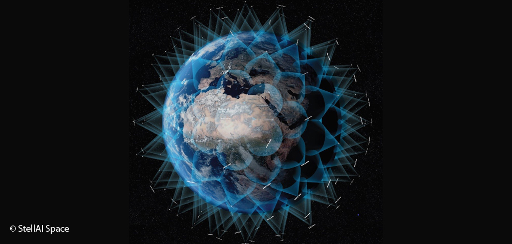
Artificial Intelligence for and from Satellite Internet Constellations
The main stakeholder in the commercial space industry are looking for ways to deploy, operate and maintain large satellite constellations at low cost. Projections indicate that in the next decade, the number of satellites in Earth‘s orbit will increase from a few thousand to hundreds of thousands. Managing such a large number of satellites manually with conventional control centres and workers will be very difficult and expensive, which is why operators and space agencies are looking for ways to automate their constellation management. This is where artificial intelligence (AI) and machine learning algorithms can provide support. Avoiding collisions with space debris, setting up and maintaining communication networks, monitoring the condition of the satellites and their operating routines are just some of the tasks that StellAI Space intends to solve with AI. The company‘s solution will use data from hundreds of satellites forming existing constellations in orbit as input for machine learning algorithms. The resulting model will be used to build a scale-up simulation with hundreds of thousands of satellites and leverage AI to achieve constellation autonomy.