Space missions generate ever-increasing amounts of data. As their complexity grows and telemetry volumes increase, ensuring the health of spacecraft becomes more challenging.
PADS is an advanced, AI-based system that automatically monitors and analyses spacecraft data in real time. This ensures higher anomaly classification accuracy and reduces false alarms. By automating anomaly detection, the system minimises the need for manual telemetry analysis, reduces operational costs and supports fleet-wide monitoring for scalable spacecraft diagnostics. It enables faster and more reliable decision-making, thereby improving mission success rates and operational efficiency.
Built on proven aerospace applications, PADS brings next-generation intelligence to satellite and launch operations, enabling smarter, safer and more efficient space missions.
Benefits:
This AI-powered anomaly detection solution enhances spacecraft reliability by predicting deviations before failures occur.
The system enables faster response times, improved data utilisation and unique insights into anomaly problematics.
Reduction of operational costs through the automatic processing of data.
Proactive, predictive model that addresses potential issues before they escalate.
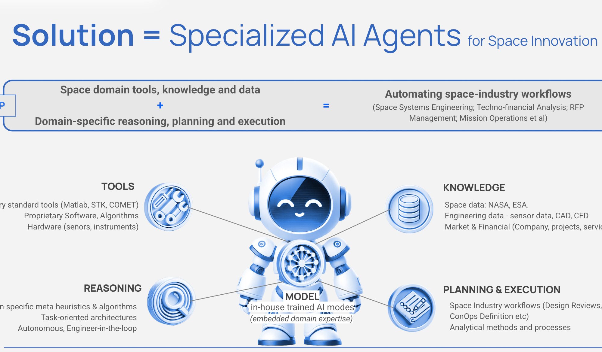
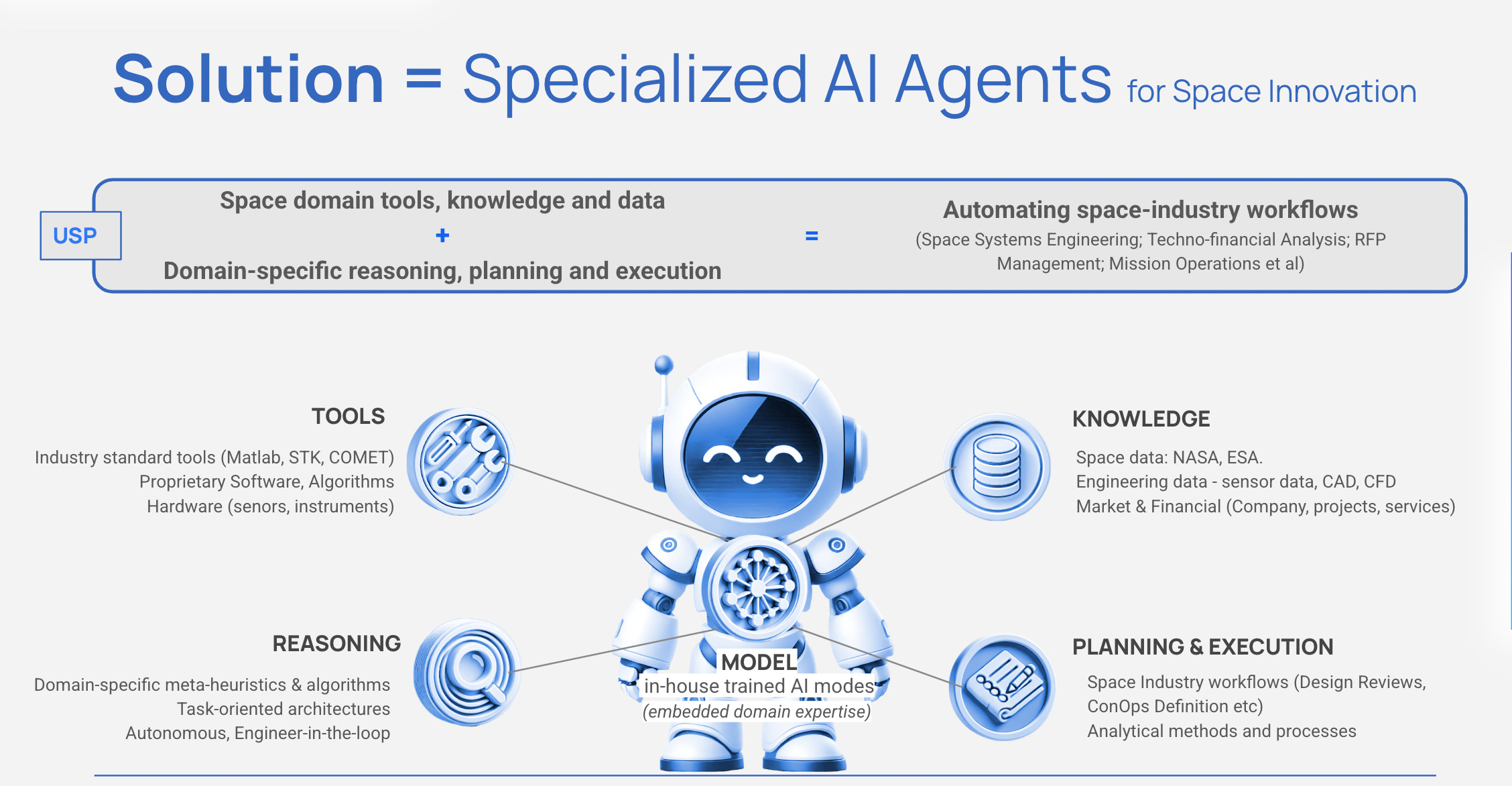
SPAIDER SPACE aims to transform space operations. With its SPAIDER AI technology, the start-up is changing the way space missions are designed, managed and executed.
The autonomous AI agents used have been specifically developed for the aerospace industry, combining state-of-the-art artificial intelligence with in-depth aerospace expertise. These specialised agents automate complex technical and business workflows that would otherwise take up valuable time from space experts. From mission planning and satellite operations to proposal development and compliance verification, SPAIDER AI takes on repetitive tasks, allowing space experts to focus on innovation. Unlike generic AI solutions, our agents understand space-specific terminology, tools, and constraints, and they integrate seamlessly with industry-standard software while preserving organisational knowledge.
SPAIDER AI represents the future of intelligent space operations, where human expertise is complemented by AI agents that work tirelessly alongside their human counterparts.
Benefits:
SPAIDER AI automates complex tasks freeing up engineers’ time to transform aerospace workflows.
For systems engineers: Agents automate requirements management, verification procedures and documentation, enabling you to focus on critical design decisions rather than paperwork.
For mission analysis experts: Agents handle repetitive trajectory calculations and analysis, accelerating planning and enabling the exploration of more design options.
For programme managers: Automated tracking, reporting and proposal development reduce project timelines and improve resource allocation.
For operations teams: Continuous monitoring agents provide a faster response to orbital events and system issues.
Parabolic Dish Killer – Dual use all sky RF digital phased array
Current satellite ground stations use mechanically gimbaled parabolic reflector antennas, also known as satellite dishes. These provide a single pencil beam, enabling communication with only one satellite at a time, and require electronic motors to steer the dish to face and track the target satellite in the sky.
Quasar’s ground station is the world’s first true digital multibeam phased array with unique all-sky capability. Its ground station supports dozens of beams simultaneously for both SATCOM and SDA missions from a single compact aperture. One array has the equivalent capacity of at least five separate 5 m parabolic dishes from a single sensor. This significantly reduces operating expenses and provides additional functionality to improve the performance of space-to-earth links.
Benefits:
Satcom bottlenecks are reduced, with no loss of passes when LEO satellites fly in swarms.
New Space Domain Awarenes insights, including the ability to detect, fingerprint and track unknown objects anywhere in the sky. Providing a comprehensive database of RF emissions at high granularity Pattern-of-Life processing provides actionable alerts for discovered anomalies.
Spectrum monitoring identifies jamming, illegal transmissions and grey zone activity.
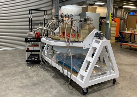
RegONE – A Modular Regolith Transportation System for Lunar Surface Operations
Humanity is on the brink of returning to the moon – with the intention to stay. This time with commercial actors alongside national space agencies, which makes it necessary to use locally available resources, such as lunar regolith (“moon dust”). It is 10 times finer than a grain of sand, extremely abrasive, electrostatically charged and floats for an exceptionally long time, making it difficult to handle.
A team of students from RWTH Aachen University offers a unique approach to this problem: the RegONE transport system. The students developed this transport system with the vision of reliably transporting regolith in a variety of lunar terrains and conditions. RegONE is vibration-based, modular and has no moving parts to minimise long-term wear and tear.
The goal of the team is to develop a TRL-6 prototype of regONE to prove its feasibility for operation on the Moon. This will require further research into interactions with the lunar soil and the design of a support structure that can be attached to the lunar surface.
Benefits:
Optimises the entire lunar value chain: higher efficiency, higher safety, lower operating costs (e.g. insurance and planning costs)
Enables the construction of a lunar outpost
Facilitates further technological development with regard to In-Situ Resource Utilisation (ISRU) and the handling of hazardous materials
Satellites generate huge amounts of data every day, and traditional methods of data analysis are struggling to keep up. By compressing and deploying AI models on satellites, data processing could be performed on board. This would drastically reduce the latency associated with downloading and analysing images at ground stations. To overcome this challenge, NinjaLABO introduces a new technology: TinyML as-a-Service (TinyMLaaS). TinyMLaaS integrates state-of-the-art edge AI solutions into satellite systems to process data directly on board, reducing the latency of communication back to the ground station and improving real-time decision making.
Until now, satellite manufacturers have mostly opted to develop the systems for such edge AI solutions themselves. However, this approach often results in unnecessarily slow development processes. NinjaLABO specialises in the core components of Edge AI frameworks, enabling satellite manufacturers to focus on improving their business value to customers, significantly reduce R&D costs and achieve faster time-to-market.
Benefits:
Real-time performance: local execution of inference without cloud computing delays for immediate data analysis
Low power consumption: optimised for low-power devices such as microcontrollers, ideal for battery-powered or low-power systems
Improved privacy: sensitive information is not sent to centralised servers
Improved cost efficiency: minimises the need for expensive, power-hungry hardware for lower operating costs
Expanded applications: enables intelligent functions in devices that were previously unsuitable due to size, cost or power constraints
SPHERICAL: High-Performance Satellite Power Systems Powered by Agile Semiconductor Design
The reliability of satellite components is critical: one third of small satellites fail prematurely, resulting in significant economic losses and increased space debris.
SPHERICAL introduces a breakthrough approach to satellite power systems. It is based on a proprietary agile semiconductor engine, software tool and supply chain. The company’s approach significantly improves the reliability and performance of Power Control and Distribution Units (PCDUs) by designing microchips specifically for satellite applications in-house and manufacturing them in Europe. As the company expands, it aims to cover a wider range of satellite subsystems and eventually offer a complete avionics module for medium satellites.
As well as revolutionising satellite subsystem technology, SPHERICAL aims to reduce Europe’s dependence on non-European sources of semiconductors, thereby strengthening its strategic autonomy in the aerospace sector. The company’s technology is capable of setting new industry standards for in-space power systems, improving the longevity, robustness and economics of satellite missions.
Benefits:
A PCDU subsystem that is 5x smaller, more affordable and better suited for mass-production compared to conventional power systems, with the added benefit of being software configurable and radiation tolerant for different orbital environments (LEO, MEO, GEO).
The advanced PCDU promises shorter integration times for satellite systems – days instead of months – and reduces one-off development costs by over €200,000.
The innovative design allows for rapid configuration changes and system updates via software – a capability not currently available in the market.
SPHERICAL is at the forefront of strengthening European sovereignty in space while addressing the global challenge of microchip dependency.
HELIOS – The next step in interplanetary transportation
Chemical and electric space thrusters occupy opposite positions on the propulsion spectrum. The choice is to use chemical propulsion with a short but strong thrust-pulse and low efficiency in fuel utilisation, or electric propulsion with continuous long-term but weak thrust and high efficiency in converting fuel into momentum for the spacecraft. There is a big gap in thruster parameters between these main thruster species; a niche for electric high-thrust propulsion like Helios. To guarantee the achievement of highly efficient fuel utilisation, the Helios high-thrust device is basically an electric propulsion system with the benefit of boosting fuel efficiency by coupling external electrical energy in thrust generation. Based on this high momentum generation per fuel particle, the Helios propulsion concept offers the capability of high momentum change per time; high thrust completes the basic benefits of electric space propulsion.
Benefits:
Helios high-thrust electric propulsion combines the flexibility of a continuous electric thruster with the powerful behaviour of a chemical-like thrust level
Ability to switch on and off on demand and to adjust the operational time
High thrust level, which is able to change the momentum of a craft with high inertia in short time
Capabilities to react to sudden disturbances and to significantly reduce travel time by reaching maximum velocity at an earlier point in the mission
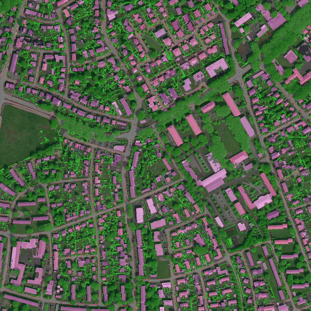
Space debris currently poses a great threat to the future of space operations, accessibility, and exploration. Due to our increased dependency on satellites, if left unaddressed, space debris can cause damage to assets in space and to life on Earth. Detecting, cataloguing, and predicting Resident Space Objects (RSO) is the first step towards solving the problem of orbital debris and having a sustainable and accessible near-Earth orbit. Current technological capabilities allow for the tracking of objects larger than 10 cm. However, the current resolution of ground-based space surveillance systems leaves 96 per cent of the approximately 1 million lethal space objects untracked, and even for the tracked 4 per cent, complex metrics (object profile and error statistics) are unavailable, rendering the tracking data operationally irrelevant. Digantara is developing a two-pronged system to address the difficulties of space operations and situational awareness through the Space Mission Assurance Platform, aka Space-MAP. Space-MAP will serve as a one-stop solution for all space operations, with products offered through a data feedback loop using multi-modal data sets. This platform will be as powerful and sophisticated as Google Maps, serving as a foundational layer for space operations and astrodynamics research. Through Space-MAP, Digantara can track objects at 10x higher resolution in daylight and in eclipse, increasing the ability to track 20x more objects.
Benefits:
One-stop portal for all space operations
Common operational picture through data fusion using multimodal data sets
Capability to track RSOs at 10x higher resolution in both daylight and eclipse
Near-real-time in-situ monitoring of space weather
We create a virtual copy of the Earth – Ready for simulation, gaming and more
Today’s virtual worlds don’t meet the key requirements of the simulation industry. For instance, to simulate an autonomous vehicle, current virtual worlds are not sufficient in quality, scale, price, and flexibility. For example, Google Earth cannot be used for simulation, as it only looks like the real world, but does not behave like the real world. AVES Reality discovered a way to solve this, by looking at the world from space, instead of visiting and mapping every place down on Earth. Our unique solution lies in our AI, which understands and then appropriately and rapidly builds up any place on Earth from satellite imagery. As we know and understand every object we reconstruct, we can apply materials and physical attributes to make the virtual world behave like the real world.
Benefits:
Rapid creation of simulation worlds enables faster R&D iterations and accelerated time to market
AI-powered world creation eliminates manual labour for 3D modelling and mobile mapping
3D worlds for autonomous vehicle R&D serve as a safe space for virtual testing without physical driving
AI analysis enables perfect synthetic data, while parameter-based 3D creation enables infinite variations
DLTEO – the one-stop shop for the earth observation data market
The Earth Observation (EO) data product market will grow exponentially to become another full-fledged commodity market, yet there are two key elements that are currently missing from it:
Low friction and barriers for users via easy-to-use interfaces that allow players in the industry chain to bypass specialists
Customisability of data processing pipelines to allow for easy fusion of different data sources to EO data, to help define new correlations and consolidate all previously fragmented value chain activities in one platform
Meanwhile, many companies have a high demand for EO data products that is either partially or fully unmet due to the difficulties of integrating into the current market. DLTEO GmbH is developing a decentralised, transparent, scalable and fair new market era. DLTEO is an AI-run, peer-to-peer and crowd-sourced EO data mining and trading „one-stop shop“. DLTEO has created a new serverless, scalable, decentralised fusion-computing paradigm enabling customised EO digital assets to be processed and traded transparently yet privately in quasi-real time at any point in the data’s lifecycle.
Benefits:
One-stop shop for all market levels (Downstream, Midstream, Upstream)
Buy/sell/process data locally or on our distributed network
Customers stay in control of their data! The data is always encrypted, safe from third parties
Fully open-source and externally auditable tech stack
Unique decentralised architecture built on cutting-edge technology
Support for complex data and processing licence agreements (subscriptions, quality guarantees, etc.)


 orbiting earth")