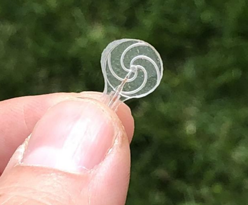
Sustained exposure to high-energy radiation can cause significant damage to both human and spacecraft life in space. Understanding the effects of radiation, as well as developing technology to counter its effects, necessitates a thorough understanding of the radiation environment. The current capability allows us to study radiation around the near-Earth environment through statistical and analytical models. However, there is a paucity of empirical data that can aid accurate assessment of the environment. Digantara intends to fill this gap through actionable intelligence by measuring proton fluence and, as a result, proton radiation in near-real-time using in-situ radiation monitors. Digantara is developing ROBI – Radiation Monitor. The name ROBI means ‚Sun‘ in Sanskrit/Bengali, signifying the extensive presence of protons in space. ROBI is a proton fluence monitor that measures proton flux in real time. High-energy protons account for 95% of any solar event. Thus, measuring proton fluence is a good measure of ionising radiation in the near-Earth environment.
From looking for life on Mars to saving lives on Earth
Every year, 15 million babies are born prematurely and 1 million die even though 75% could have been saved if they had been given proper care. However, modern neonatal care is too complex and costly to be given to all, and simpler, safer, and cheaper medical technology must be developed to end preventable child mortality. A good example of this need is blood gas monitoring, which is an important method to monitor the health of preterm infants, but suffers from considerable complexity and safety problems that limit its usefulness. For example, it requires the skin to be heated to harmful levels and needs to be attached with strong adhesives that risk tearing the skin. We use patented gas sensor technology that we initially developed to look for signs of past or present life on Mars to perform blood gas monitoring in a completely novel way. Thanks to this sensor’s unique properties, our prototype requires neither heating nor adhesives to perform the measurements and, hence, can facilitate both safer and simpler monitoring of the infants’ health.
Benefits:
Gas sensor for planetary exploration that found use in neonatal care
Unique features enable the removal of harmful practices in conventional solutions
Shows how space technology can create simpler, safer, and more accessible neonatal care
ALReCo – Orbit Recycling’s new composite material for sustainable Moon exploration
Humans are heading back to the Moon. Artemis and the Lunar Gateway programme are on their way and the next step will be the lunar ground station. But one major problem for a sustainable outpost on the Moon remains: Moon dust (regolith) doesn’t have the right material properties to either store energy efficiently or to be an ideal construction material. The result would be to transport massive quantities of material from the Earth. Orbit Recycling has developed a new composite: ALReCo. Using a unique method, regolith is mixed with material from space debris to enhance its physical properties. ALReCo shows improved thermal capacity and conductivity in order to store energy much better. ALReCo is better suited to construction elements and the integration of aluminium structures, and flanges with regolith parts could become a modular framework for the upcoming Moon base. By turning waste into valuable material, ALReCo reduces not only the amount of space debris but the amount of material that needs to be transported from Earth as well.
Benefits:
ALReCo enables a self-paying space debris recycling concept
ALReCo reduces material transportation during the construction of the lunar ground station
ALReCo offers flexible use cases, from construction elements to energy storage solutions
Versatile approach for cloudless optical satellite data
In Earth observation, clouds and shadows are the most limiting factors for consistent and up-to-date imagery. While optical satellite data can be retrieved daily, actionable insights are much rarer. To overcome this lack of cloudless data, large identical satellite constellations are required. However, this only improves one’s chance of actionable insights while ignoring the root cause. Less than perfect data is still not utilised in this process and is often even difficult to identify. ClearSky Vision addresses these problems by integrating data from various missions (Sentinel-1, Sentinel-2, Landsat 8, and more) while using a novel neural network to predict urban and landscape changes underneath the cloud cover. This data fusion process is repeatable on different satellites. This allows for more consistent and frequent retrieval of multi-spectral cloudless satellite imagery and indices that are crucial to improved time-series analysis and anomaly detection. Satellites with different instruments and revisit speeds can be utilised in synergy, thereby combining the best features of different satellites.
Benefits:
The most up-to-date cloudless optical imagery (updated daily)
Enables utilisation of multiple different satellites for the same application
Enables affordable continuous monitoring for large areas
Highly versatile and efficient data fusion process
DigiFarm – detecting the world’s most accurate field boundaries to power precision agriculture
All precision agriculture services start with accurate field boundaries and seeded acres. Unfortunately, the problem is that one is making critical decisions based on inaccurate data, cadastral field boundary data, which is affecting the entire agricultural value chain. DigiFarm has spent the last two years developing a deep-resolution algorithm for Sentinel-2 imagery to increase image resolution by 10x from 10m to 1m, coupled with a deep neural network model to automatically detect field boundaries on a large scale. DigiFarm has delineated over 15 million ha across the world and has achieved an average (IoU) accuracy of above 0.96, which represents up to 20% greater accuracy than existing cadastral map data. DigiFarm delivers four key models to B2B and B2G clients through various API endpoints, including: automatic field boundary detection (and seeded acres), deep resolution of Sentinel-2 at 1m resolution on demand, automatic delineation of in-field productivity zones and crop classification, the ability to automatically detect field boundaries (seeded acres) using deep neural network models and super-high-resolution satellite imagery.
Benefits:
Deep neural network model to delineate field boundaries and seeded acres
Deep neural network model for the deep resolution of Sentinel-2 (10x) to 1m per pixel resolution, achieving sub-metre georeference accuracy
Packaged products in APIs with simple integration and setup
Easy SaaS pricing for B2B and B2G clients starting at EUR 0.03 per hectare/year
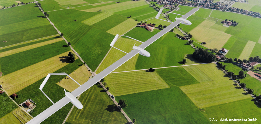
The civil UAV market with a worldwide market volume of USD 6.56 billion in 2018 is expected to grow to USD 43 billion by 2024*. Market growth in the coming years will be driven by the large number of new commercial applications, in particular by the use of unmanned stratospheric flight systems for telecommunications and Earth observation services. For perennial operation at high altitudes, these aircraft require an extremely large wingspan with the lowest possible structural weight. When flying in the troposphere, conventional aircraft configurations face a particular risk that greater turbulences could lead to cracks and fractures in the aircraft structure. The Berlin-based company AlphaLink Engineering GmbH is currently developing a compound aircraft that can solve this structural-mechanical lightweight construction dilemma by connecting multiple aircraft modules at their wingtips through mechanical joints. After intensive research at Technische Universität Berlin, the patented technology is now being tested by AlphaLink in the form of test vehicles and flight trials. The compound aircraft is the first electrically powered stratospheric aircraft that achieves both long operating times and high payloads.
* SESAR, European ATM Master Plan, Roadmap for the safe integration of drones into all classes of airspace, 2018
Benefits:
Secure, unmanned operation for low-cost Internet access in remote areas
First flying platform with a modular approach
Technology is fully scalable as a complement and alternative to satellite systems
Year-round operation possible just powered by solar energy
Can be used as “flying camera” or “mobile antenna”
GNSS common-view – Time and frequency synchronisation for industry
Time synchronisation is a basic requirement for operating important infrastructures in almost all industrial sectors worldwide, such as the energy, telecommunications, transport and financial sectors. The high demands on the accuracy of time measurement, which is currently in the single-digit nanosecond range, are an essential driver of technology and innovation to take time measurement into ever new dimensions. Time synchronisation is traditionally achieved via cable protocols with their own network timing. The use of such dedicated networks is not always possible for financial or logistical reasons, such as for systems operating on different continents (finance), in densely populated urban areas (5G or IoT) or for highly decentralised systems (blockchain). Melior Systems GmbH is working on a cost-effective, global system solution for highly accurate time synchronisation based on the atomic clocks of navigation satellites (GNSS) in combination with exact time comparisons using what is known as the common-view method. The system solution is offered to infrastructure operators and other customers as a software licence in conjunction with support services.
Benefits:
Time and frequency synchronisation based on GNSS with 1-digit nanosecond accuracy
Cost-effective deployment independent of the link distance to synchronise
Reduced costs of infrastructure in urban areas and improved indoor GNSS reception
Tikal – Remote assessment of remote traffic routes
Only 20% of the world’s road network is paved, making it particularly vulnerable to environmental, weather and vehicle-related damage. The monitoring of unpaved roads is of high relevance as they are also used to transport people and goods. There are currently no IT-based methods that can be used to continuously record and analyse the condition of the road over a wide area. Within the framework of the Tikal project, BAREWAYS GmbH is developing a software system that can determine the current and future road condition by means of pattern recognition, even from inhomogeneous and incomplete data sets. For this purpose, a wide variety of data sources such as weather forecasts, maps, satellite images, and vehicle sensors are aggregated, calibrated and analysed with the help of Artificial Intelligence (AI). This current road condition information is made available to the vehicle navigation system together with other criteria for route planning and optimisation such as vehicle type, fragility of the load or safety needs of the driver.
Benefits:
Prediction of road conditions in rural areas that are not covered today
The fusion of vehicle sensors, satellite imagery, and weather forecasts
Flexible routing to account for individual vehicle capabilities
Applicable to other transport lines such as railways and power lines
AgSat – An Ideal Optical-Thermal Platform for Agricultural and Environmental Remote Sensing
The growing human population, associated challenges related to climate change, and the insufficiency of existing terrestrial sensing systems require new sources of Earth observation (EO) data. Critical parameters like non-photosynthetic vegetation (NPV) and evapotranspiration (ET) are not properly estimated by existing operational EO systems. NPV is important for estimating fire risk, tillage intensity, and the risk of soil erosion due to water and wind. ET is important for agricultural production and water usage. AgSat will offer an advanced multispectral satellite concept that will not only measure those parameters, but also include on-board artificial intelligence and data processing to minimise data downloads while using laser-based systems for more efficient data transmission. AgSat will deliver custom, need-driven, cloud-free data products directly to stakeholders within minutes of acquisition. Science data will be available to end users under an open data policy.
Benefits:
Data continuity with Sentinel-2/Landsat missions
Open data for science products
On-board anomalous event detection (fires, floods) and data product creation, including downlinking to end users