Space debris currently poses a great threat to the future of space operations, accessibility, and exploration. Due to our increased dependency on satellites, if left unaddressed, space debris can cause damage to assets in space and to life on Earth. Detecting, cataloguing, and predicting Resident Space Objects (RSO) is the first step towards solving the problem of orbital debris and having a sustainable and accessible near-Earth orbit. Current technological capabilities allow for the tracking of objects larger than 10 cm. However, the current resolution of ground-based space surveillance systems leaves 96 per cent of the approximately 1 million lethal space objects untracked, and even for the tracked 4 per cent, complex metrics (object profile and error statistics) are unavailable, rendering the tracking data operationally irrelevant. Digantara is developing a two-pronged system to address the difficulties of space operations and situational awareness through the Space Mission Assurance Platform, aka Space-MAP. Space-MAP will serve as a one-stop solution for all space operations, with products offered through a data feedback loop using multi-modal data sets. This platform will be as powerful and sophisticated as Google Maps, serving as a foundational layer for space operations and astrodynamics research. Through Space-MAP, Digantara can track objects at 10x higher resolution in daylight and in eclipse, increasing the ability to track 20x more objects.
Benefits:
One-stop portal for all space operations
Common operational picture through data fusion using multimodal data sets
Capability to track RSOs at 10x higher resolution in both daylight and eclipse
Near-real-time in-situ monitoring of space weather
We create a virtual copy of the Earth – Ready for simulation, gaming and more
Today’s virtual worlds don’t meet the key requirements of the simulation industry. For instance, to simulate an autonomous vehicle, current virtual worlds are not sufficient in quality, scale, price, and flexibility. For example, Google Earth cannot be used for simulation, as it only looks like the real world, but does not behave like the real world. AVES Reality discovered a way to solve this, by looking at the world from space, instead of visiting and mapping every place down on Earth. Our unique solution lies in our AI, which understands and then appropriately and rapidly builds up any place on Earth from satellite imagery. As we know and understand every object we reconstruct, we can apply materials and physical attributes to make the virtual world behave like the real world.
Benefits:
Rapid creation of simulation worlds enables faster R&D iterations and accelerated time to market
AI-powered world creation eliminates manual labour for 3D modelling and mobile mapping
3D worlds for autonomous vehicle R&D serve as a safe space for virtual testing without physical driving
AI analysis enables perfect synthetic data, while parameter-based 3D creation enables infinite variations
Lane-level navigation provides value for drivers with better ETA (estimated time of arrival) management, and more personalised and better anticipation for stress-free driving. Geoflex‘ high-accuracy lane-level positioning can be fitted in pretty much any car, with or without cameras. Moreover, high-accuracy lane-level map data can be crowdsourced at scale using the same vehicles. This creates a virtuous circle where the car with its positioning can detect new lane geometries, which can be sent to a map server to add to the coverage. The innovation relies on software algorithms that can be easily integrated into the navigation stack without complex integration with a computer vision system. There is no hardware upgrade needed and the new car position at decimeter accuracy can be broadcast to the navigation software instead of a standard GNSS feed. The positioning service is available worldwide, it leverages the 4 GNSS constellations (GPS, Galileo, Beidu, Glonass) and can be fused with other sensors with high integrity.
Benefits:
Improve car positioning from metric accuracy to centimetric accuracy
Maximise the value of GNSS, the only absolute positioning technology available in a car
Improve the integrity and availability of multi-sensor positioning engines
Leverage a wide range of applications from navigation to autonomous driving
Next-generation satellite navigation from LEO for autonomous vehicles and other modern applications
Nearly every form of modern transportation now relies on the free GPS (GNSS) services as provided by major governments, and as we enter the age of autonomy this reliance is getting stronger. However many navigation services are based on an architecture that was designed nearly a half-century ago, and are failing to meet the requirements needed for modern systems to operate safely when it comes to accuracy, security, and resilience. Xona is leveraging the advacements of the new space era to develop Pulsar: a constellation of small but powerful navigation satellites in low Earth orbit, more than 20x closer to Earth than GPS. Pulsar will provide secure navigation services that are more than 100x stronger and 10x more accurate than GPS, enabling reliable sub-10cm level positioning anywhere on Earth. Xona’s patent-pending distributed atomic-clock architecture is at the core of Pulsar which allows high-performance services to be provided from small satellites without the need for large atomic clocks onboard.
Benefits:
Sub 10-cm accuracy without any external corrections
Over 100x more powerful and resistant to interference than current GNSS
Secure service protected by encryption and authentication to support safety-critical applications
LEO small sat architecture allows for affordable servies globally
Massive and broad market potential – over 6 billion devices already using GNSS today
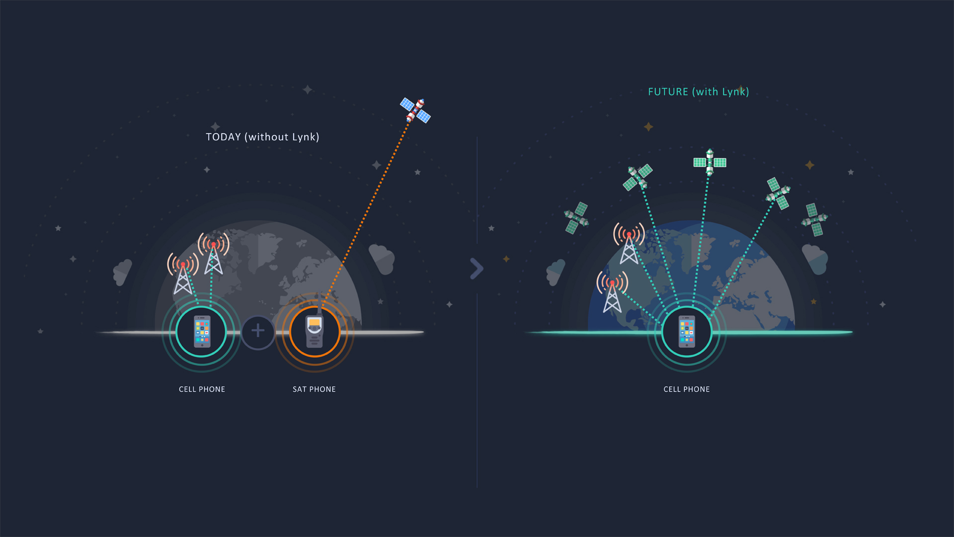
Satellite-direct-to-phone service everywhere on the planet
Currently, about 90% of the planet and 75% of the Earth’s landmass has no cell tower connectivity either because it is not economical (very low-density areas) or physically impossible (in the ocean). Building land-based cell towers in uncovered regions is economically unsustainable. Lynk’s transformative global communications solution moves the traditional cell tower onto small satellites in Low Earth Orbit. Lynk’s constellation provides direct connectivity to 3GPP standard mobile devices on the ground including mobile phones and cellular IoT devices. Lynk’s patented technology compensates for Doppler shift (the cell tower is moving relative to the mobile device) and extended range time delay cell tower is now ~500 km from the mobile device) to provide global affordable mobile coverage. In 2021, Lynk proved its technology by connecting thousands of mobile devices across five countries with Lynk’s fifth satellite, Shannon. This technical milestone is the first step in connecting everyone everywhere outside terrestrial tower coverage using their existing, unmodified mobile devices. On April 1, 2022, Lynk launched its first commercial-ready satellite enabling the company to begin providing commercial service later in 2022.
Benefits:
Ubiquitous global mobile coverage for billions of people
Mobile network resiliency not impacted by natural disasters
Alleviating digital poverty in remote or dispersed communities

 orbiting earth")