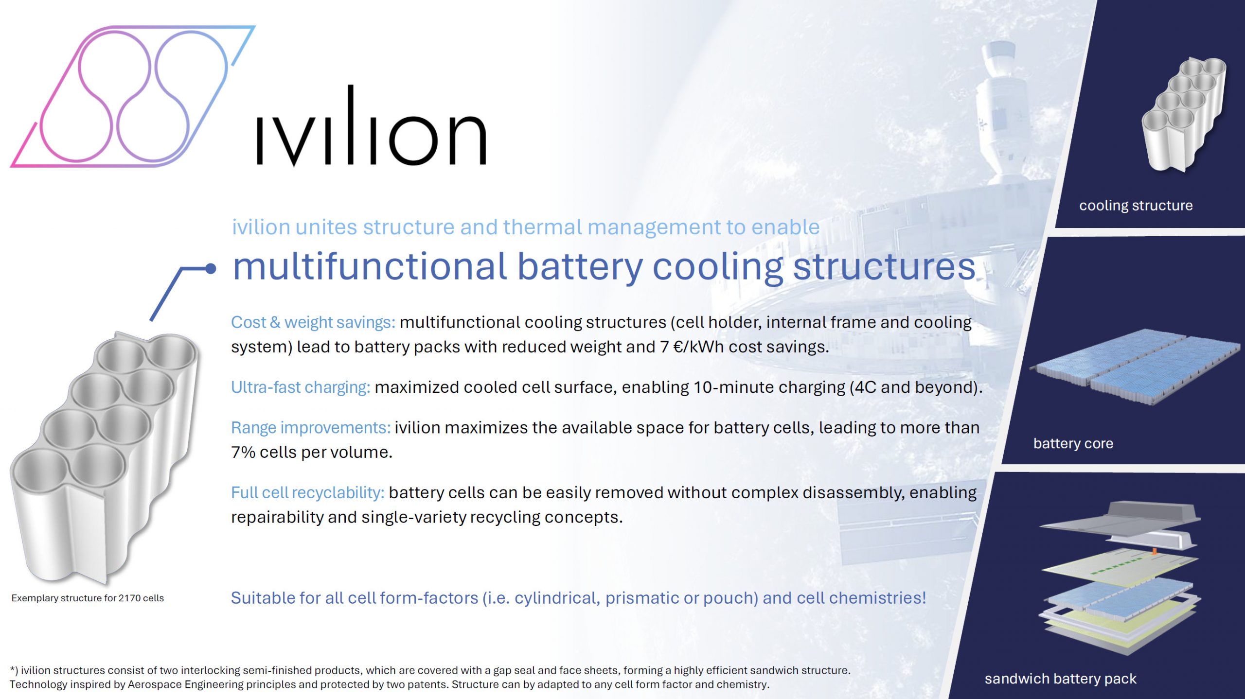
ivilion – Multifunctional structural cooling for EVs
Electric vehicles (EVs) face several key challenges, particularly high costs, long charging times, and limited range. Fast charging is critical to accelerating EV adoption, but it typically generates significant heat, which is often managed only through complex and costly immersion cooling systems.
ivilion GmbH addresses this challenge with innovative battery cooling solutions and advanced battery pack designs for mobility applications. At the core of its technology is a multifunctional cooling structure that simultaneously acts as a cell holder, thermal management system, and structural element of the battery pack. These structures can be directly integrated into the battery, reducing the number of components and system complexity.
This multifunctionality enables cost savings of up to €7 per kWh and improves energy density at the pack level. Additionally, the significantly enlarged cooled surface area achieves cooling performance comparable to immersion systems, allowing for high C-rates during fast charging.
ivilion’s technology supports faster charging, longer driving ranges, and lower production costs—and is compatible with all cell formats and chemistries.
Benefits:
Cost and weight savings for battery packs through multifunctional cooling structures.
Improved range: ivilion maximises the available space for battery cells, resulting in more than 7% cells per volume.
Complete recyclability of the cells: Battery cells can be easily removed without complicated disassembly, enabling repairability and single-origin recycling concepts.
From Space to Street – Transferring SAR to transform automotive sensing with realistic radar simulation
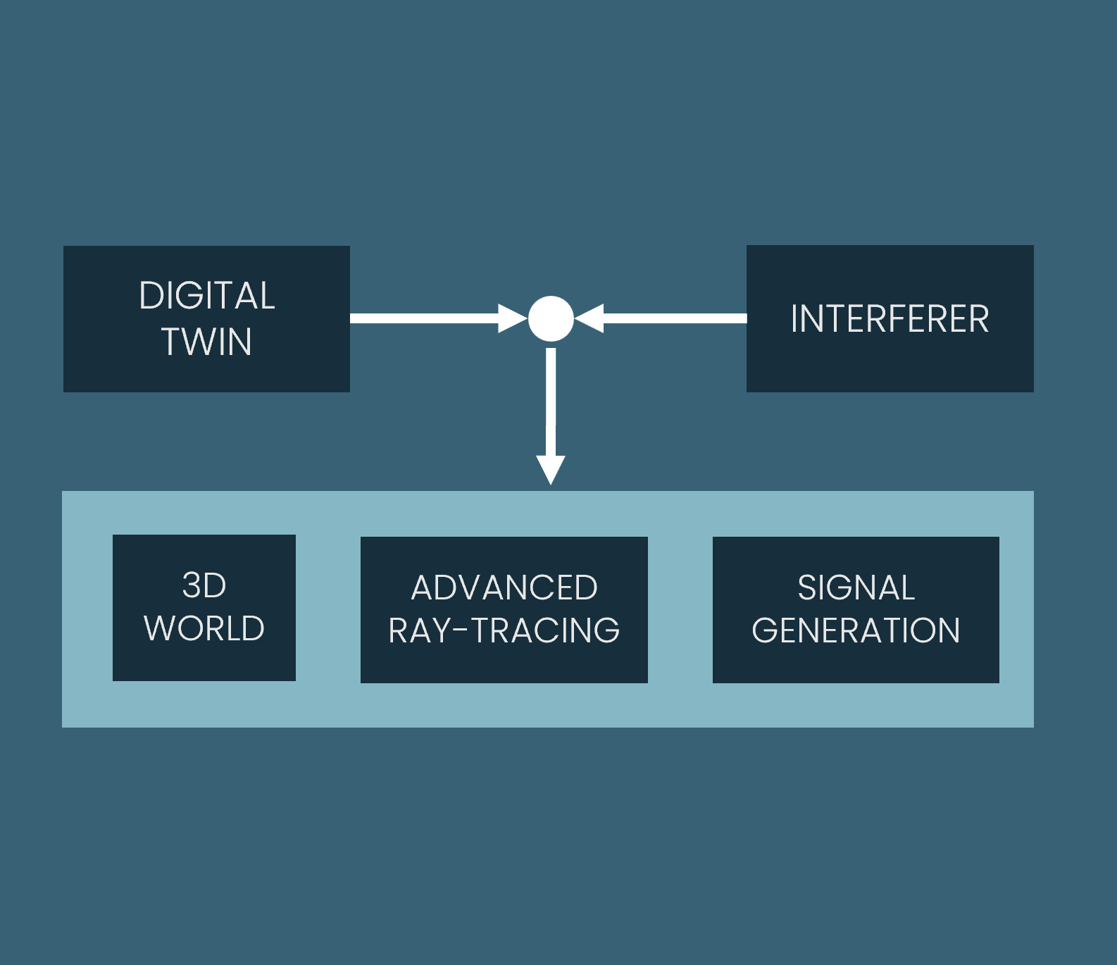
It has been used in space for decades – now it’s time for radar to come to the road. Synthetic Aperture Radar (SAR), the technology behind some of the most precise earth observation satellites, is finally making its way into the automotive world as a key technology that makes autonomous vehicles safe and reliable.
Today’s radar sensors in the automotive world still struggle with resolution and performance in complex environments. fiveD is changing this by bringing the power of SAR from space to the road. Using a purpose-built simulation platform, fiveD can virtually test how SAR-based radar can dramatically improve perception in challenging driving scenarios – such as complex urban environments or fast-moving motorways. This enables faster and more cost-effective development of next-generation radar systems without relying on expensive physical prototypes. This solution lays the foundation for smarter, more powerful radar – helping to unlock the future of safe and fully autonomous mobility.
Benefits:
By enabling physically accurate simulation early in the design process, users can explore and validate concepts before building hardware – leading to faster iteration cycles and significant cost savings.
Engineers benefit from realistic modelling of wave-level radar effects, enabling them to develop better sensors, algorithms and perception systems.
Simulation enables scalable generation of different data sets for AI training and improves performance in edge cases without costly real-world data collection.
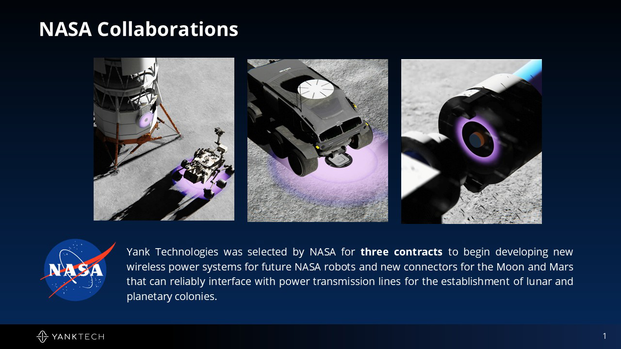
Harsh environmental conditions prevail on the surface of the moon, which are mainly due to the so-called regolith. Its insulating properties at the electrical interfaces of the rovers, such as the power connections, pose a significant risk for any mission. The wireless power supply can mitigate the problems of the electrical interfaces. However, current wireless charging systems are very sensitive to charging distance (less than 1 cm), have very low end-to-end efficiency, and rely on the use of robots to connect the rover to the charging station.
Yank Technologies solves these problems by using its Magnetic Resonant technology to deliver power over distances of up to half a metre, similar to WiFi but for power. This wireless charging system can operate efficiently in extreme misalignment and without robotic intervention, greatly improving operations on the lunar surface.
The technology can also be used in the automotive sector: Wireless power architectures can supply power to complete subsystems such as seats, doors, lighting and infotainment in vehicles, significantly reducing the wiring harness.
Benefits:
Wireless transmission technology using a patented Inductive Resonant technology capable of transmitting energy up to 0.50 metres through materials with high efficiency, without the limited distance, axial alignment, thermal rise and lack of efficiency inherent in conventional inductive solutions.
Efficient operation even with extreme misalignment and without the use of robots, significantly improving the operation of rovers on the lunar surface.
Direct power provision solutions for consumer electronics, industrial robots and automobiles.
Managing Supply Chain and Infrastructure With Earth Observation Data
Global supply chains and the complex logistics operations that support them are the backbone of today’s economy. Responding quickly to disruptions is critical to minimising costs and delays. Better still, predict and prevent them.
Black Sky offers BlackSky Spectra®, a proactive Early Warning System (EWS) for managing supply chains and logistics infrastructure such as ports, by combining space-based monitoring with AI-powered predictive analytics. To achieve this, they have developed and combined Spectra™ AI and & Spectra™ Tasking. These technologies fuse data from BlackSky’s own high-resolution Low Earth Orbit (LEO) satellite constellation and other third-party sensors to develop critical insights and analytics for decision makers in real time.
By leveraging this secure, low-latency tasking to deliver high-resolution, time-varying imagery and analysis, decision makers can draw on space assets to inform the full spectrum of strategic planning through tactical missions worldwide.
Benefits:
High-frequency monitoring of the world’s most important strategic locations, economic assets and events
Actionable intelligence from capture to delivery in less than 90 minutes, up to 15 times a day
Easily accessible platform for all users, optimised for agility
No geospatial expertise required for the application user
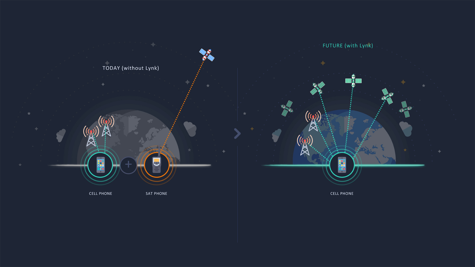
Internet access on Europe’s highways is pretty poor. This doesn’t just annoy passengers, it also hampers mobility applications that rely on connectivity, preventing European carmakers from realising the full potential of automotive digitalisation.
Stellar is a deep-tech company that aims to revolutionise connectivity in mobility through hybrid telecommunications. The company’s ambition is to bring seamless connectivity to all vehicles, enabling reliable internet access at all times and on all roads. Stellar has therefore developed its Car-as-a-Service software, STEER, which enables seamless switching between cellular, Wi-Fi and satellite networks- while ensuring maximum service availability, packet loss free switching and aggregation of multiple networks for optimal throughput. STEER is designed to meet automotive-grade requirements for safety, reliability and cybersecurity, and can be seamlessly integrated into new car ranges. It can also be retrofitted to existing car models or even trains through a hardware module.
Benefits:
Reliable and secure Internet access in moving vehicles such as cars and trains
Seamless switching between cellular, Wi-Fi and satellite networks
Integration into new models and retrofitting to existing car and train models
Device connectivity is the holy grail of our digital age: By allowing physical devices to connect and communicate with each other, we have been able to increase economic output. Examples include the Internet, satellite communications or, more recently, the Internet of Things (IoT). But all existing networks share some fundamental shortcomings: They are often proprietary, expensive, power-hungry, unscalable and, worst of all, lacking in coverage.
The Hubble Network aims to change that. Hubble is building a constellation of Low Earth Orbit (LEO) satellites to enable a global, low-cost, low-power network that can scale to billions of devices – using Bluetooth Low Energy (BLE). Using their patented innovative satellite antenna design, Hubble have demonstrated that they can connect any Bluetooth device directly to satellites in LEO – without any additional infrastructure. This level of connectivity has the potential to revolutionise many different industries, including agriculture, logistics, mobility and defence.
Benefits:
Enables data exchange directly with satellites by connecting any Bluetooth device directly to space
Enables an unprecedented level of connectivity while using existing commercial-of-the-shelf Bluetooth chips
Easy integration with any existing BLE chip – no additional infrastructure required
Lane-level navigation provides value for drivers with better ETA (estimated time of arrival) management, and more personalised and better anticipation for stress-free driving. Geoflex‘ high-accuracy lane-level positioning can be fitted in pretty much any car, with or without cameras. Moreover, high-accuracy lane-level map data can be crowdsourced at scale using the same vehicles. This creates a virtuous circle where the car with its positioning can detect new lane geometries, which can be sent to a map server to add to the coverage. The innovation relies on software algorithms that can be easily integrated into the navigation stack without complex integration with a computer vision system. There is no hardware upgrade needed and the new car position at decimeter accuracy can be broadcast to the navigation software instead of a standard GNSS feed. The positioning service is available worldwide, it leverages the 4 GNSS constellations (GPS, Galileo, Beidu, Glonass) and can be fused with other sensors with high integrity.
Benefits:
Improve car positioning from metric accuracy to centimetric accuracy
Maximise the value of GNSS, the only absolute positioning technology available in a car
Improve the integrity and availability of multi-sensor positioning engines
Leverage a wide range of applications from navigation to autonomous driving
Next-generation satellite navigation from LEO for autonomous vehicles and other modern applications
Nearly every form of modern transportation now relies on the free GPS (GNSS) services as provided by major governments, and as we enter the age of autonomy this reliance is getting stronger. However many navigation services are based on an architecture that was designed nearly a half-century ago, and are failing to meet the requirements needed for modern systems to operate safely when it comes to accuracy, security, and resilience. Xona is leveraging the advacements of the new space era to develop Pulsar: a constellation of small but powerful navigation satellites in low Earth orbit, more than 20x closer to Earth than GPS. Pulsar will provide secure navigation services that are more than 100x stronger and 10x more accurate than GPS, enabling reliable sub-10cm level positioning anywhere on Earth. Xona’s patent-pending distributed atomic-clock architecture is at the core of Pulsar which allows high-performance services to be provided from small satellites without the need for large atomic clocks onboard.
Benefits:
Sub 10-cm accuracy without any external corrections
Over 100x more powerful and resistant to interference than current GNSS
Secure service protected by encryption and authentication to support safety-critical applications
LEO small sat architecture allows for affordable servies globally
Massive and broad market potential – over 6 billion devices already using GNSS today
Satellite-direct-to-phone service everywhere on the planet
Currently, about 90% of the planet and 75% of the Earth’s landmass has no cell tower connectivity either because it is not economical (very low-density areas) or physically impossible (in the ocean). Building land-based cell towers in uncovered regions is economically unsustainable. Lynk’s transformative global communications solution moves the traditional cell tower onto small satellites in Low Earth Orbit. Lynk’s constellation provides direct connectivity to 3GPP standard mobile devices on the ground including mobile phones and cellular IoT devices. Lynk’s patented technology compensates for Doppler shift (the cell tower is moving relative to the mobile device) and extended range time delay cell tower is now ~500 km from the mobile device) to provide global affordable mobile coverage. In 2021, Lynk proved its technology by connecting thousands of mobile devices across five countries with Lynk’s fifth satellite, Shannon. This technical milestone is the first step in connecting everyone everywhere outside terrestrial tower coverage using their existing, unmodified mobile devices. On April 1, 2022, Lynk launched its first commercial-ready satellite enabling the company to begin providing commercial service later in 2022.
Benefits:
Ubiquitous global mobile coverage for billions of people
Mobile network resiliency not impacted by natural disasters
Alleviating digital poverty in remote or dispersed communities