Monitoring of traffic routes by a solar-electric-powered ultralight aircraft and innovative multi-sensor 3D capturing and processing technology
Extreme weather events such as storms and drought as well as pest infestation weaken the vegetation alongside railways and roads, which can endanger operational safety. The Deutsche Bahn invests up to 125 million euros each year in the inspection and management of the tree vegetation along the railway infrastructure. Elektra Solar and RealityMaps have developed a new geodata acquisition system that significantly improves existing technologies for assessing and monitoring the health condition of the vegetation alongside railways. It consists of an environmentally friendly, solar-electric-powered ultralight aircraft, a multi-sensor 3D camera system and AI-based data evaluation. This unique system makes it possible to record aerial images, 3D elevation, thermal imagery and multispectral data simultaneously in one flight. Productivity is much higher, while providing a similar spatial resolution to UAVs.
Benefits:
Extremely efficient and environmentally friendly collection of spatial data from the air
Detailed recording of the health condition of the vegetation with a multi-sensor 3D camera system
Digitisation of up to 400 km of railways per day
Also suitable for road management and monitoring of construction measures (BIM)
Calculation of virtual 3D models and digital twins with a level of detail that has never been achieved before
With a rapidly changing climate and the emergence of readily available satellite imagery, there exists both the need and opportunity to switch over from an interval-based to a needs-based approach for the maintenance of infrastructure assets – HACARUS’s innovation helps enable this shift. Current solutions for AI-based image analysis typically require large, well-defined data sets for creating AI models. In addition, these often fail when applied to real-world scenarios due to sensitivity over discrepancies between data used for training and observed data. HACARUS’s solution is powered by its proprietary sparse modelling-based AI engine, which is uniquely adept at overcoming these challenges – the core algorithms allow for the creation of highly accurate AI models from small data sets, which means it is also able to quickly add new objects of interest. This allows for an AI system that is able to adapt to changes over time, and that can provide an instant bird’s eye view of an asset’s current health. The human-centric design, including smart features such as heat maps and bounding boxes, provides operators with actionable insights for smarter maintenance operations.
Benefits:
Enables a shift from interval-based to needs-based maintenance
Provides instant insights at a glance concerning object location & change over time
Allows for maintenance and surveillance work to be performed remotely
PhySens GmbH – magnetic rail infrastructure monitoring
Digital rail infrastructure monitoring is vital for future rail mobility. Especially for autonomous train operation, knowledge of the exact position of, e.g., a switch, is required at all times. Current systems are based on a mechanical measurement principle or operate indirectly by analysing, e.g., the current consumption of switch actuators. As a result, they provide non-continuous feedback on the real position or movements of components, which can lead to false alarms. In this case, tracks need to be closed until the components are examined, which causes delays. The new system for digital, wireless monitoring of rail infrastructure, developed by PhySens GmbH, is based on a high-precision magnetic measurement principle. The standardised, easily retrofittable sensor monitors data from switches, railroad crossings or signals, which are processed in the cloud. Using the system, the exact position of switch components or railroad crossing barriers can be determined precisely. In addition, information about the current mechanical state is provided and can be used for predictive maintenance. In this way, the system decreases delays, while simultaneously reducing maintenance costs and extending the lifetime of infrastructures.
Benefits:
Retrofittable, standardised system for infrastructure monitoring
Mechanically robust and maintenance-free sensor and cloud-based data processing
Prevention of track closures and costly maintenance work
DLTEO – the one-stop shop for the earth observation data market
The Earth Observation (EO) data product market will grow exponentially to become another full-fledged commodity market, yet there are two key elements that are currently missing from it:
Low friction and barriers for users via easy-to-use interfaces that allow players in the industry chain to bypass specialists
Customisability of data processing pipelines to allow for easy fusion of different data sources to EO data, to help define new correlations and consolidate all previously fragmented value chain activities in one platform
Meanwhile, many companies have a high demand for EO data products that is either partially or fully unmet due to the difficulties of integrating into the current market. DLTEO GmbH is developing a decentralised, transparent, scalable and fair new market era. DLTEO is an AI-run, peer-to-peer and crowd-sourced EO data mining and trading „one-stop shop“. DLTEO has created a new serverless, scalable, decentralised fusion-computing paradigm enabling customised EO digital assets to be processed and traded transparently yet privately in quasi-real time at any point in the data’s lifecycle.
Benefits:
One-stop shop for all market levels (Downstream, Midstream, Upstream)
Buy/sell/process data locally or on our distributed network
Customers stay in control of their data! The data is always encrypted, safe from third parties
Fully open-source and externally auditable tech stack
Unique decentralised architecture built on cutting-edge technology
Support for complex data and processing licence agreements (subscriptions, quality guarantees, etc.)
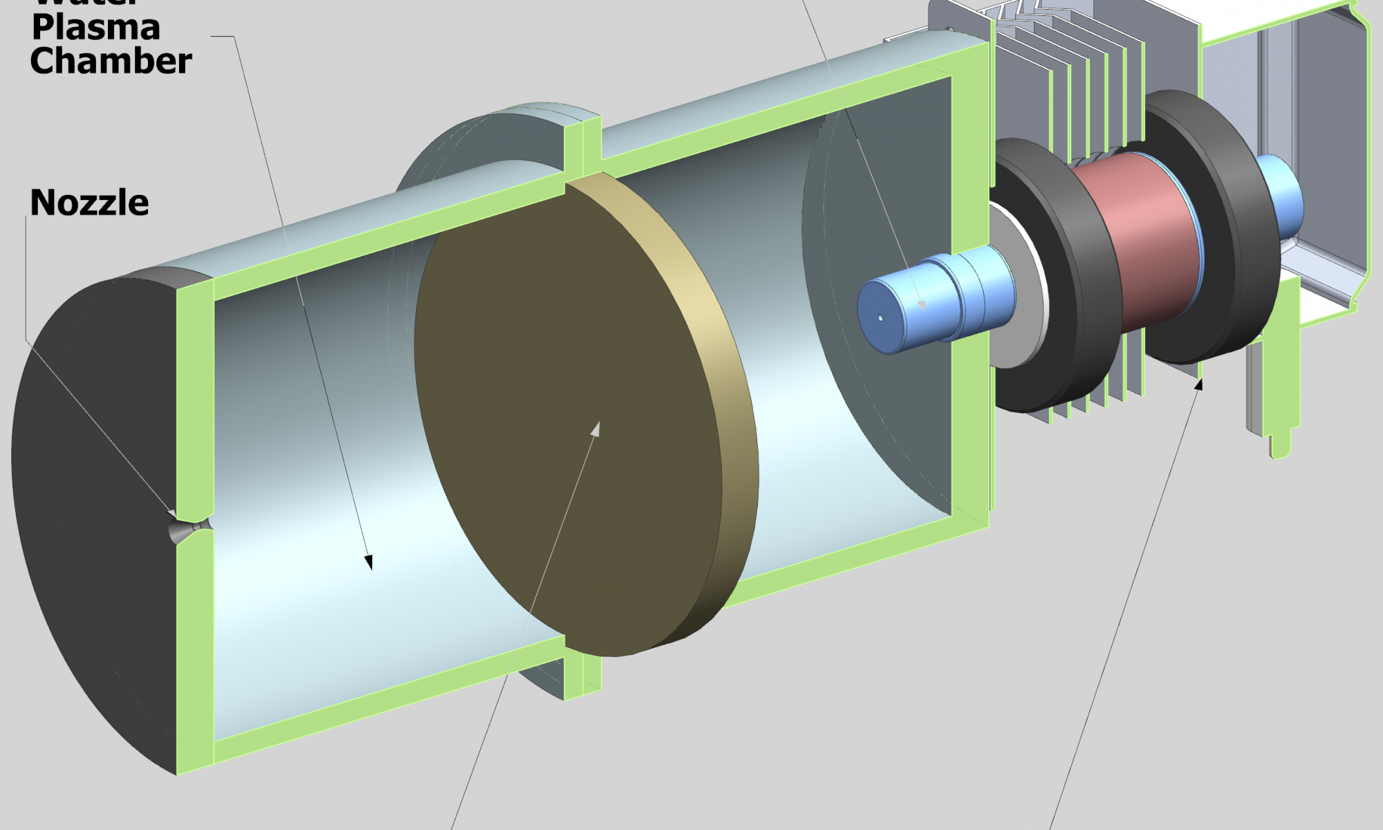
Sustainable spacecraft propulsion by water as the expellant mass
Water is abundant in the solar system. It can be found on the Moon, Mars, the icy moons of Jupiter and on smaller celestial bodies such as asteroids. Considering that it is a must for long-term human presence in space and that it can be used for many purposes, such as radiation shielding or energy storage, it is also conceivable to use it as a propellant or expellant in a propulsion system. It has ideal properties as an expellant: high density, a liquid state at low energy conditions, it is unharmful and simple to handle. Heating the water to plasma state and expanding it in a nozzle forms a highly effective, yet simple, type of electric propulsion system. The high achievable temperature enables a significant saving in propellant mass over chemical in-orbit propulsion systems. The author’s proposal is to make use of advancements in electronics and manufacturing to push this known concept to a new stage within a joint research project. Earlier laboratory demonstrators used bulky and inflexible magnetrons with a high voltage input. A new type of solid-state microwave generator enables a lightweight design and excellent tunability at a low voltage, yet with a high power level. Contactless, low-wear heating of a green expellant such as water open up an excellent opportunity within propulsion technology. The simplicity of such a propellant also reduces the risk assessment of the system in general and on rideshare missions.
Benefits:
Water as a cheap, green expellant
Simple, long-term reliability due to contactless heating
Uncomplicated approval process due to high safety
Greater payload than for chemical propulsion systems
The ever-growing amount of space debris is a critical threat to the space industry and jeopardises the essential services provided to clients all over the world. Although the potential for cascading collisions was outlined many decades ago, no active countermeasures to remove debris from orbit have yet been realised. DEBRIS is a small satellite for active debris removal. It utilises its geometry-independent, multi-capturing-capable mechanism to attach to target objects. After establishing physical contact with its target, DEBRIS employs passive devices — a drag sail and a tether — to deorbit them with great flexibility. From an economic perspective, DEBRIS renders active space debris removal profitable. Key cost-reducing features are its rideshare-optimised design, commercial off-the-shelf components, as well as its low development and operational costs. DEBRIS’s cost-effectiveness and scalability make it unique among other proposals for active space debris removal.
Benefits:
Small satellite solution for active space debris removal
Micro G Scope (MGS) is an innovative approach to the problem of biological testing in space, using an innovative fluorescence contact CMOS microscope and special growing chamber in a CubeSat. The technical requirements for space biology are enormous, and the effort to reduce the cost while maintaining precision and safety is huge. The project’s goal is to solve the problem of the accessibility (and cost) of biological tests in space by providing not only an instrument for biological experiments, but a whole service for pharma and bio-tech companies that will include: experiment design, cell preparation microscale fluorescence microscope, and calibration chamber. In addition, the microlaboratory could be easily modified to accommodate alternative experiments such as seed and spore germination, embryology studies, and the production of nutrients in space, among others. Micro G Scope‘s first design is aimed at testing cancer drugs in space to extract information on whether these drugs work under reduced gravity conditions. The project is currently at SRR level (System Requirements Review) through PDR (Preliminary Design Review).
Benefits:
New cell chamber and microscope design for biological experiments in space based on a lensless design with no moving parts and the size of a credit card
Reduced cost and time to perform the experiments
New full service for the pharma industry where experiment preparation, mission accomplishments, and data review are transparent for the client
ALReCo – Orbit Recycling’s new composite material for sustainable Moon exploration
Humans are heading back to the Moon. Artemis and the Lunar Gateway programme are on their way and the next step will be the lunar ground station. But one major problem for a sustainable outpost on the Moon remains: Moon dust (regolith) doesn’t have the right material properties to either store energy efficiently or to be an ideal construction material. The result would be to transport massive quantities of material from the Earth. Orbit Recycling has developed a new composite: ALReCo. Using a unique method, regolith is mixed with material from space debris to enhance its physical properties. ALReCo shows improved thermal capacity and conductivity in order to store energy much better. ALReCo is better suited to construction elements and the integration of aluminium structures, and flanges with regolith parts could become a modular framework for the upcoming Moon base. By turning waste into valuable material, ALReCo reduces not only the amount of space debris but the amount of material that needs to be transported from Earth as well.
Benefits:
ALReCo enables a self-paying space debris recycling concept
ALReCo reduces material transportation during the construction of the lunar ground station
ALReCo offers flexible use cases, from construction elements to energy storage solutions
Versatile approach for cloudless optical satellite data
In Earth observation, clouds and shadows are the most limiting factors for consistent and up-to-date imagery. While optical satellite data can be retrieved daily, actionable insights are much rarer. To overcome this lack of cloudless data, large identical satellite constellations are required. However, this only improves one’s chance of actionable insights while ignoring the root cause. Less than perfect data is still not utilised in this process and is often even difficult to identify. ClearSky Vision addresses these problems by integrating data from various missions (Sentinel-1, Sentinel-2, Landsat 8, and more) while using a novel neural network to predict urban and landscape changes underneath the cloud cover. This data fusion process is repeatable on different satellites. This allows for more consistent and frequent retrieval of multi-spectral cloudless satellite imagery and indices that are crucial to improved time-series analysis and anomaly detection. Satellites with different instruments and revisit speeds can be utilised in synergy, thereby combining the best features of different satellites.
Benefits:
The most up-to-date cloudless optical imagery (updated daily)
Enables utilisation of multiple different satellites for the same application
Enables affordable continuous monitoring for large areas
Highly versatile and efficient data fusion process
DigiFarm – detecting the world’s most accurate field boundaries to power precision agriculture
All precision agriculture services start with accurate field boundaries and seeded acres. Unfortunately, the problem is that one is making critical decisions based on inaccurate data, cadastral field boundary data, which is affecting the entire agricultural value chain. DigiFarm has spent the last two years developing a deep-resolution algorithm for Sentinel-2 imagery to increase image resolution by 10x from 10m to 1m, coupled with a deep neural network model to automatically detect field boundaries on a large scale. DigiFarm has delineated over 15 million ha across the world and has achieved an average (IoU) accuracy of above 0.96, which represents up to 20% greater accuracy than existing cadastral map data. DigiFarm delivers four key models to B2B and B2G clients through various API endpoints, including: automatic field boundary detection (and seeded acres), deep resolution of Sentinel-2 at 1m resolution on demand, automatic delineation of in-field productivity zones and crop classification, the ability to automatically detect field boundaries (seeded acres) using deep neural network models and super-high-resolution satellite imagery.
Benefits:
Deep neural network model to delineate field boundaries and seeded acres
Deep neural network model for the deep resolution of Sentinel-2 (10x) to 1m per pixel resolution, achieving sub-metre georeference accuracy
Packaged products in APIs with simple integration and setup
Easy SaaS pricing for B2B and B2G clients starting at EUR 0.03 per hectare/year