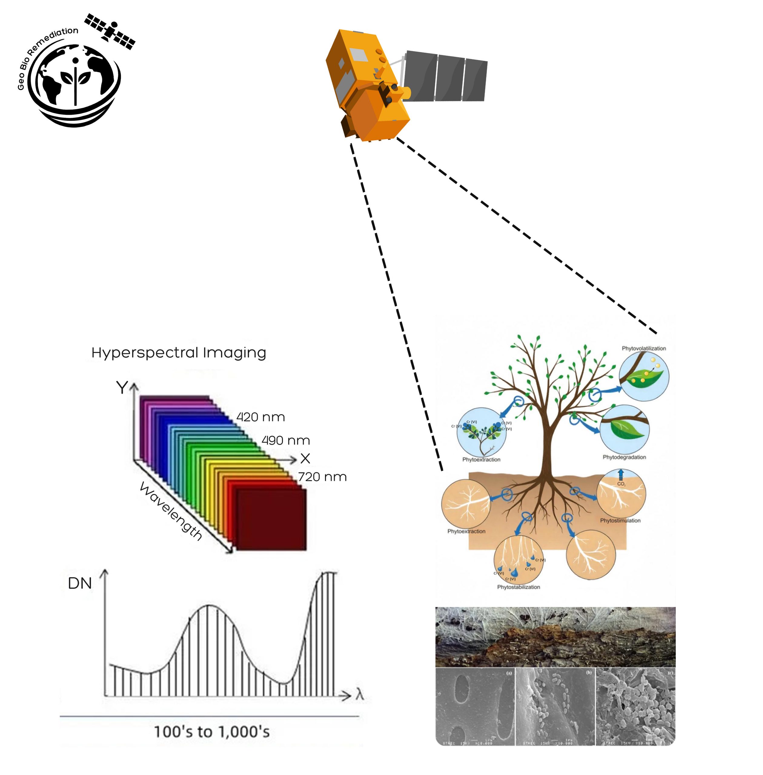
Heavy metal pollution from industries such as mining, electroplating and leather tanning affects millions of hectares of land around the world, threatening biodiversity and human health.
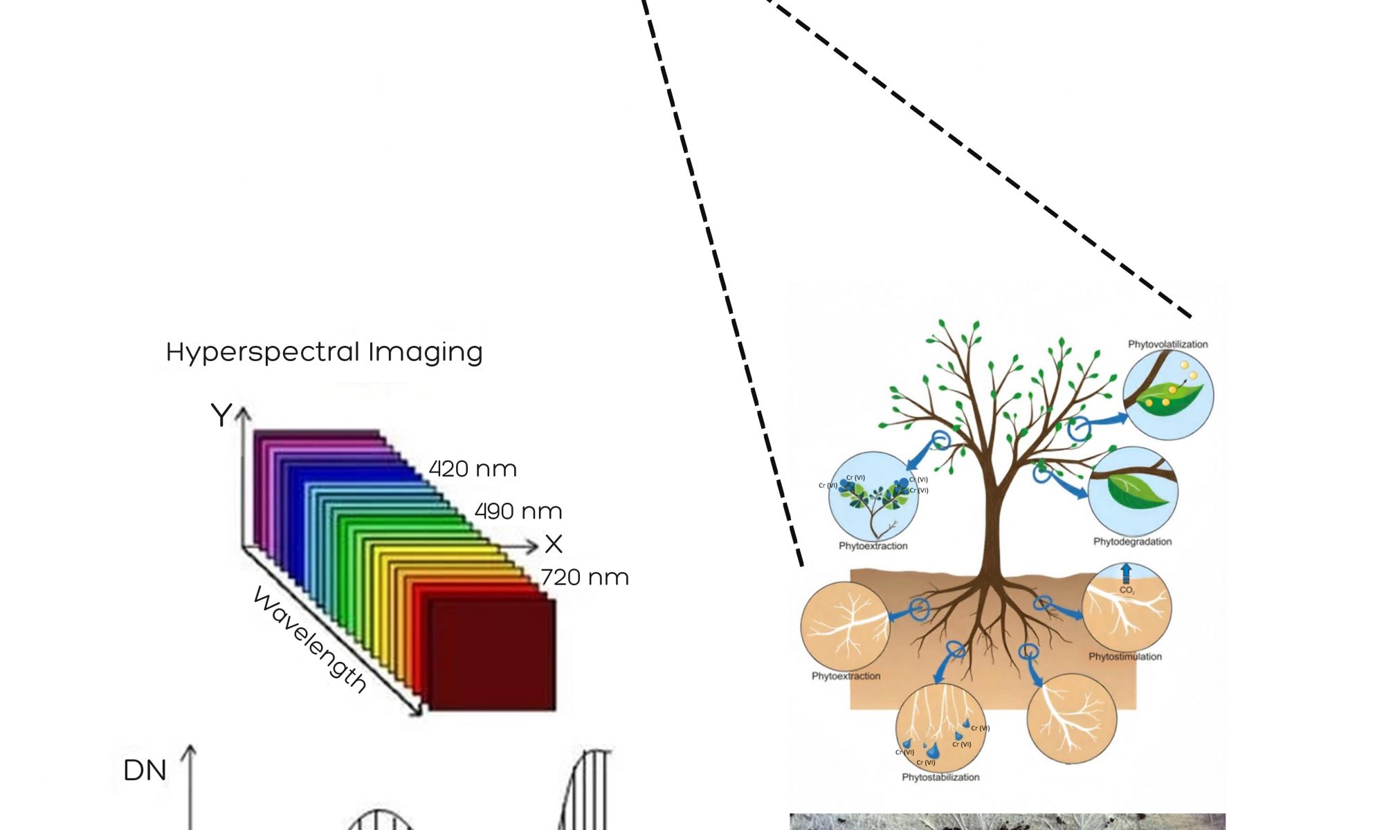
GeoBioRemediation is an innovative solution that uses space technology and AI-driven analytics alongside bioremediation techniques to tackle heavy metal pollution in soil and water. By using Sentinel-2, EnMAP hyperspectral imaging, and IoT sensors, it enables real-time monitoring of contamination and provides predictive insights, thereby empowering industries, municipalities, and policymakers to take action. The project offers a cost-effective, scalable, and sustainable alternative to traditional remediation methods by integrating biochar-bacteria reactive zones and phytoremediation. Its applications span the mining, manufacturing, agricultural, and biodiversity conservation sectors, supporting global environmental and climate resilience efforts.
Benefits:
Cost savings: Reduces site survey and remediation costs by up to 70%.
Faster detection: Contamination is detected in days instead of months.
Automated monitoring: AI-powered continuous surveillance eliminates the need for expensive manual sampling.
Sustainable clean-up: Biochar-bacteria zones, phytoremediation and microbial bioremediation safely convert toxic Cr(VI) to Cr(III).
FlyPix AI – Democratising Earth observation for a sustainable future
Efforts to promote sustainability are hindered by the difficulty of translating Earth Observation (EO) data into actionable insights. Monitoring environmental issues such as illegal waste disposal, deforestation, tree health and land degradation requires specialised AI models, technical expertise and costly manual annotation. This renders EO analytics inaccessible to many municipalities, NGOs and small organisations that urgently require scalable, affordable tools to address local and global sustainability challenges.
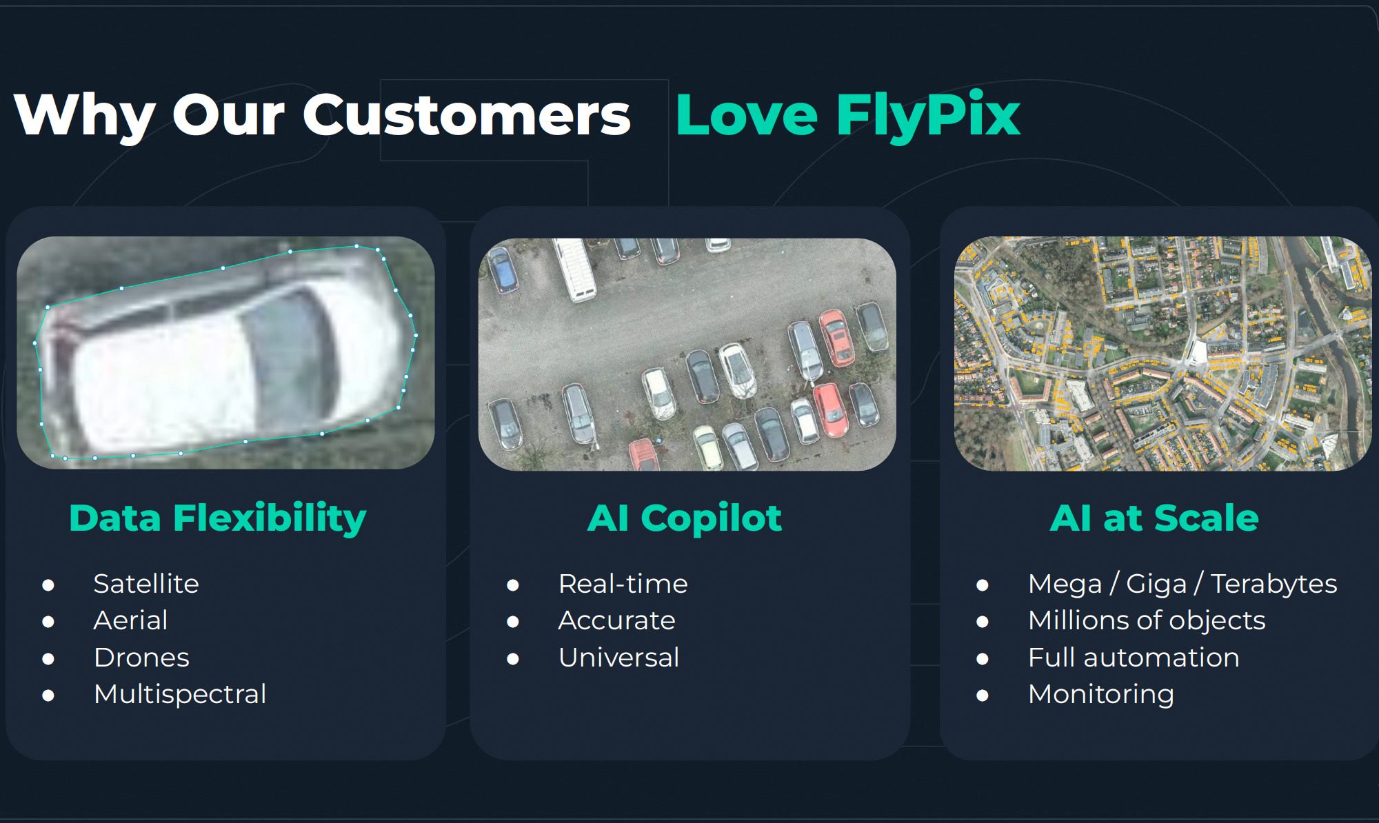
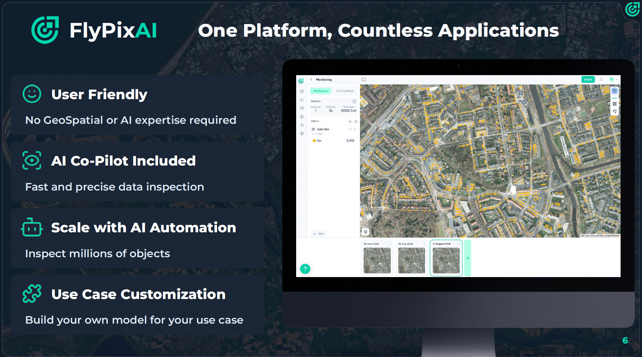
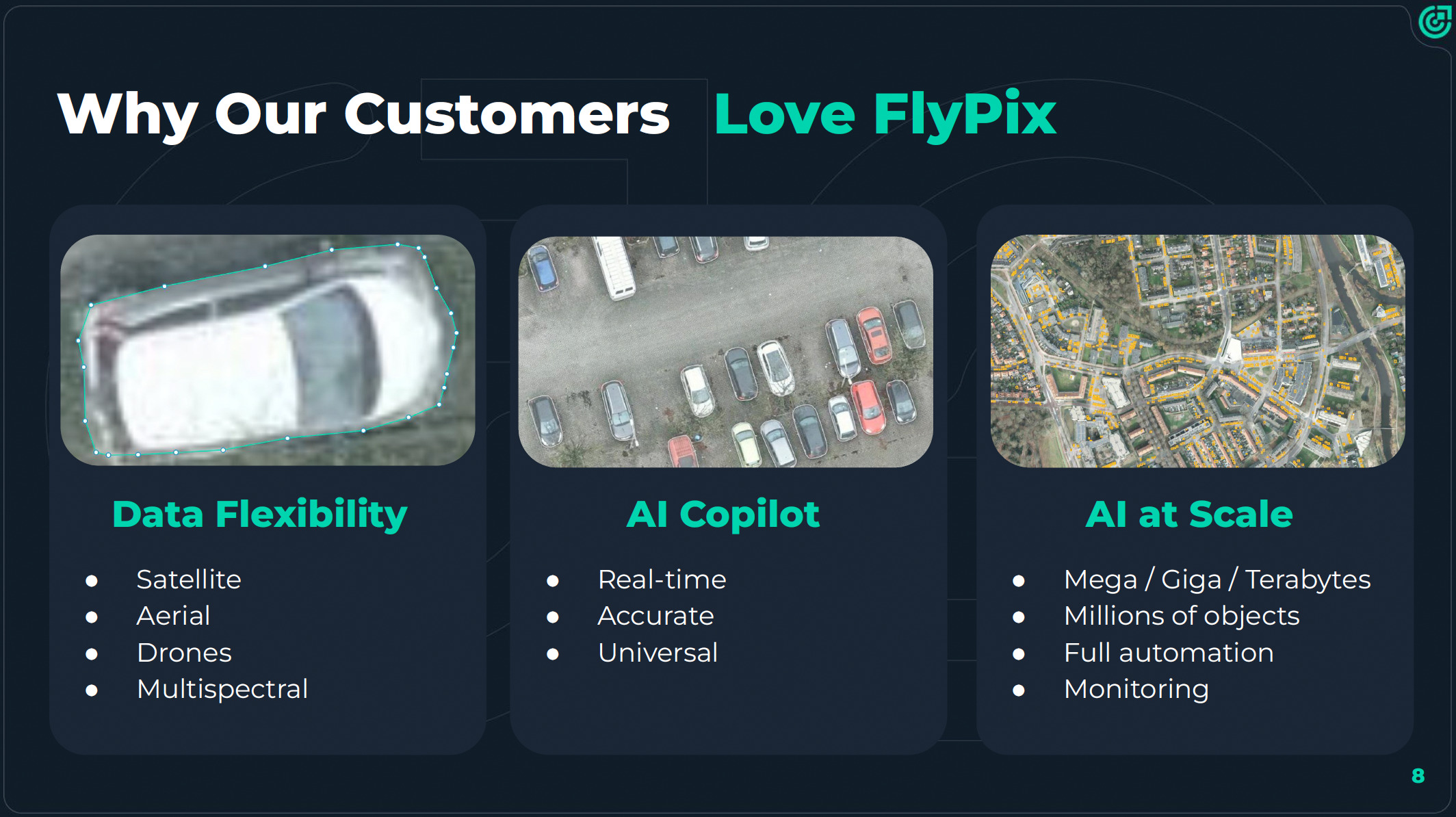
FlyPix AI overcomes the technical and financial barriers that have prevented most organisations from accessing AI-powered sustainability monitoring. The Software as a Service (SaaS) platform integrates seamlessly into diverse workflows and transforms complex satellite and drone data into clear, actionable insights — without any technical expertise required. Whether monitoring cities, forests or infrastructure, FlyPix AI provides businesses, municipalities and organisations of all sizes with access to advanced geospatial analytics at a fraction of the cost, empowering them to make smarter decisions faster.
Benefits:
Major cost and time savings: Users can create AI models with just a few annotations, reducing costs by up to 97% and analysis time by 95%.
No-code usability: The platform enables non-experts to detect rubbish, count trees or track land changes using a simple four-step workflow.
Scalable and versatile: From small areas to citywide zones.
Better decisions: Faster automated dashboards and visual outputs improve transparency and speed up sustainability-related decision-making.
Easy integration with APIs and web dashboards: FlyPix AI can be integrated into existing systems and workflows with minimal setup.
Space-driven remote audit solutions for sustainability
Climate change poses significant challenges to Europe, including an increased frequency of extreme weather events such as floods, heatwaves and droughts. These events threaten infrastructure, water resources and public health.
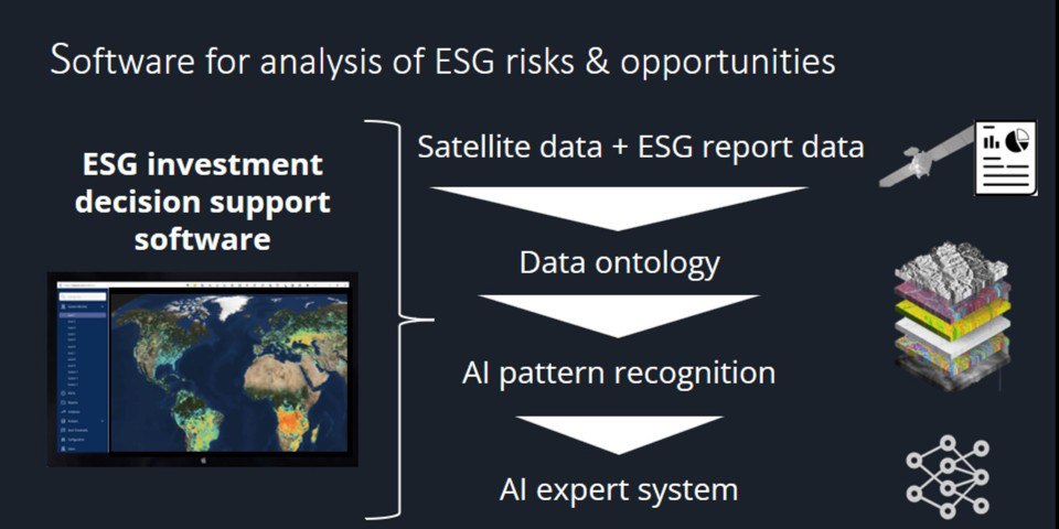
Current Earth observation solutions for forecasting these events often rely on limited sensors or general satellite data, providing reactive insights and slower diagnosis. WeavAir is transforming Environmental, Social and Governance (ESG) data analytics by combining satellite imaging, Internet of Things (IoT) sensors and predictive AI models to create real-time digital twins of buildings and infrastructure. By tracking over 20 factors, including energy use, carbon emissions, and climate resilience, WeavAir provides highly accurate insights, enabling faster and more informed decision-making. Our system helps operators to reduce operational costs and energy consumption while improving air quality and mitigating climate and insurance risks.
Benefits:
Real-time, highly accurate environmental data enabling smarter, faster decision-making in sustainability efforts.
A 200x faster diagnosis of the core factors affecting energy use, emissions and climate resilience.
30% savings in operational and maintenance costs, over 20% energy savings and improved air quality while significantly reducing carbon emissions and climate-related risks.
Diagnostics accuracy of 95%, with no need for recalibration.
Miura Nexus: Physics-Informed Machine Learning Technology: A Use Case in Optimal Process Design.
Physical simulation is a powerful but time-consuming tool for engineers. Both data generation and analysis are time intensive – the iterative process requires many cycles to define a viable solution.
The rgenerated results are difficult to evaluate, visualise and communicate. In addition, physical simulations in aerospace industrial processes, especially with complex engineering components and advanced materials, lead to significant variations that make it difficult to predict production quality prior to implementation.
Miura aims to overcome these challenges in development and high-end manufacturing processes by using PIML technology to develop a predictive quality analysis tool. This tool supports simulation engineers and factory operators in making informed decisions.
By using this technology, Miura provides an in-depth and physically based simulation of part quality that is particularly suited to manufacturing processes that involve complex physical transformations.
Benefits:
Physics-informed machine learning (PIML) technology to help simulation engineers make improved decisions
Proprietary technology to accelerate design exploration and improve process design
Real-time tablet performance
Engineers and operators can use the generated models as predictive components integrated into their workstations
These models not only predict part quality, but also provide recommendations for optimal process parameters for each part
Imaging Technology (PAIS) That Allows Very High Resolution Visable Imagery (10cm) from Low-Cost Satellites
Satellite imagery with a resolution of 10 cm is currently not commercially available. Such a high resolution can only be achieved with very expensive satellites, which cannot be scaled up to a cost-effective constellation with global monitoring capabilities.
Remondo is developing an innovative imaging technology that can achieve this very high resolution (10 cm) using low-cost satellites in LEO. While the best commercial satellites currently have a resolution of 30 cm and exceed costs of several hundred million EUR, the cost of a single satellite in this case is 2 orders of magnitude lower. This makes it possible to build a large constellation that can provide global, persistent monitoring for multiple applications. This will break the current boundaries of the entire Earth observation market and thus enables new applications.
Benefits:
High-resolution satellite imagery (10 cm) at a cost saving of 2 orders of magnitude per satellite compared to current approaches
Enabling the cost-efficient establishment of a global satellite constellation for daily coverage of high-accuracy Earth observation data
Facilitation of new applications and use cases with Earth observation data
eClypse: Onboard, Tamper-Proof Cyber Security Intrusion Detection for Satellites with Ground Segment Telemetry
Satellites are an essential part of our critical infrastructure, providing services such as navigation, communication and Earth Observation. Recent cybersecurity challenges in the telecom supply chain and a rising number of criminal and state-sponsored actors are seeking to disrupt communications demonstrate: There is no secure communications infrastructure without adequate cyber defences.
DISC has developed a hardware-based intrusion detection module for satellites called eClypse. It requires no processing or storage resources on the satellite and cannot be manipulated by an attacker. The development of this TRL6 prototype was supported by innovation funding from the Canadian Department of National Defence. It has been proven in a Magellan Aerospace laboratory and, as a result of our development and security design process, can be integrated into any satellite platform.
The next step for DISC is to create a secure satellite prototype ready for a space mission. This will take eClypse to TRL8, ready for a subsequent mission at TRL9.
Benefits
Enhanced cyber-security and privacy for all users of satellite services
Can be integrated into any satellite platform
Enables platform operators to continuously monitor the internal security status of their platform
Does not require processing or storage resources
Hardware-based approach enables protection against remote tampering by 3rd party actors
eClypse Dominant Information Solutions Canada (DISC) Marc Kneppers marc@dominantisc.ca
Sustained exposure to high-energy radiation can cause significant damage to both human and spacecraft life in space. Understanding the effects of radiation, as well as developing technology to counter its effects, necessitates a thorough understanding of the radiation environment. The current capability allows us to study radiation around the near-Earth environment through statistical and analytical models. However, there is a paucity of empirical data that can aid accurate assessment of the environment. Digantara intends to fill this gap through actionable intelligence by measuring proton fluence and, as a result, proton radiation in near-real-time using in-situ radiation monitors. Digantara is developing ROBI – Radiation Monitor. The name ROBI means ‚Sun‘ in Sanskrit/Bengali, signifying the extensive presence of protons in space. ROBI is a proton fluence monitor that measures proton flux in real time. High-energy protons account for 95% of any solar event. Thus, measuring proton fluence is a good measure of ionising radiation in the near-Earth environment.
From looking for life on Mars to saving lives on Earth
Every year, 15 million babies are born prematurely and 1 million die even though 75% could have been saved if they had been given proper care. However, modern neonatal care is too complex and costly to be given to all, and simpler, safer, and cheaper medical technology must be developed to end preventable child mortality. A good example of this need is blood gas monitoring, which is an important method to monitor the health of preterm infants, but suffers from considerable complexity and safety problems that limit its usefulness. For example, it requires the skin to be heated to harmful levels and needs to be attached with strong adhesives that risk tearing the skin. We use patented gas sensor technology that we initially developed to look for signs of past or present life on Mars to perform blood gas monitoring in a completely novel way. Thanks to this sensor’s unique properties, our prototype requires neither heating nor adhesives to perform the measurements and, hence, can facilitate both safer and simpler monitoring of the infants’ health.
Benefits:
Gas sensor for planetary exploration that found use in neonatal care
Unique features enable the removal of harmful practices in conventional solutions
Shows how space technology can create simpler, safer, and more accessible neonatal care
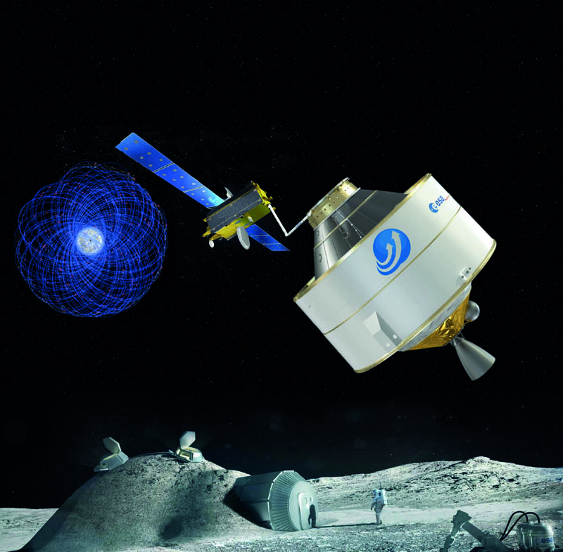
ALReCo – Orbit Recycling’s new composite material for sustainable Moon exploration
Humans are heading back to the Moon. Artemis and the Lunar Gateway programme are on their way and the next step will be the lunar ground station. But one major problem for a sustainable outpost on the Moon remains: Moon dust (regolith) doesn’t have the right material properties to either store energy efficiently or to be an ideal construction material. The result would be to transport massive quantities of material from the Earth. Orbit Recycling has developed a new composite: ALReCo. Using a unique method, regolith is mixed with material from space debris to enhance its physical properties. ALReCo shows improved thermal capacity and conductivity in order to store energy much better. ALReCo is better suited to construction elements and the integration of aluminium structures, and flanges with regolith parts could become a modular framework for the upcoming Moon base. By turning waste into valuable material, ALReCo reduces not only the amount of space debris but the amount of material that needs to be transported from Earth as well.
Benefits:
ALReCo enables a self-paying space debris recycling concept
ALReCo reduces material transportation during the construction of the lunar ground station
ALReCo offers flexible use cases, from construction elements to energy storage solutions