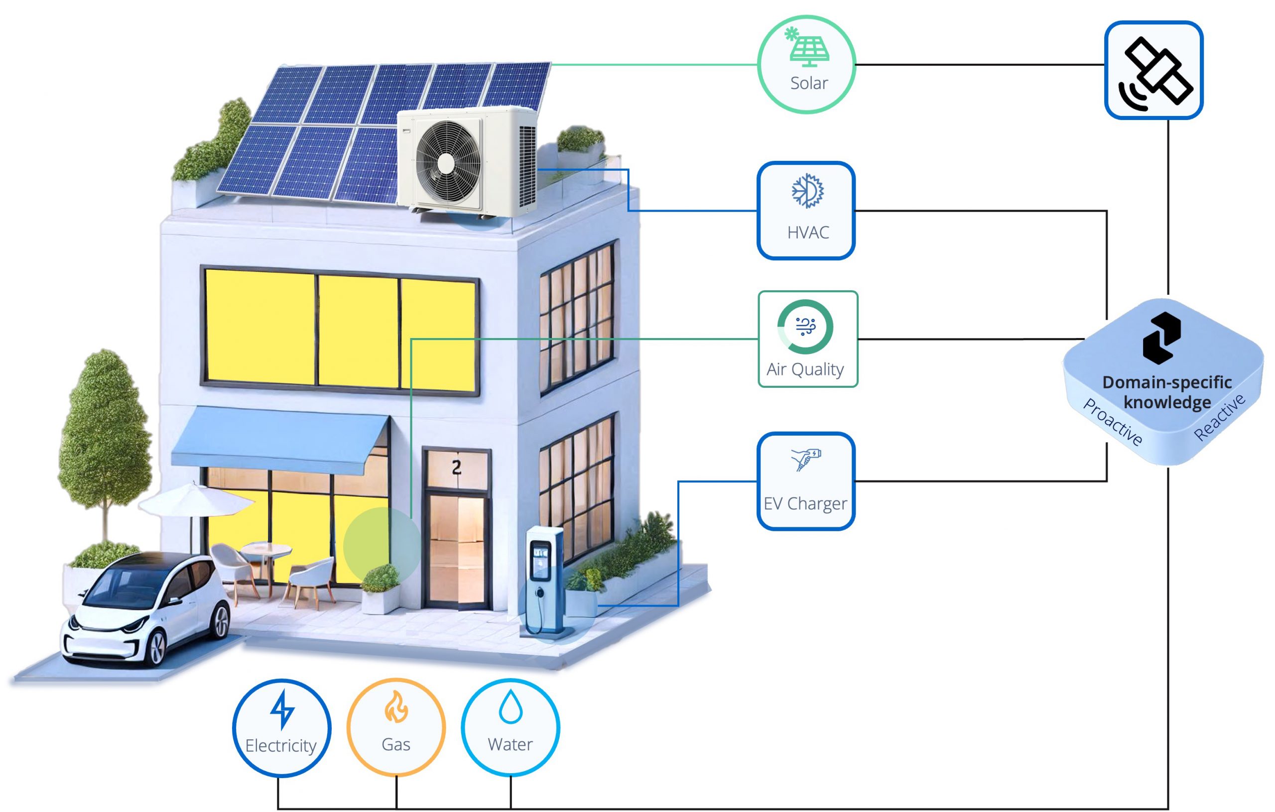
Preflet – The most adaptive AI powered energy manager & avoided emission reporting
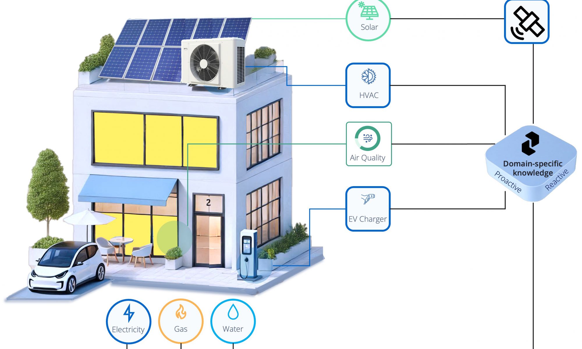
Preflet is an AI-powered platform designed to analyse and reduce building energy consumption. It identifies the causes of energy losses and suggests ways to reduce consumption, helping building managers to lower their carbon footprint and costs.
The platform combines cutting-edge, AI-driven energy optimisation with satellite data and IoT technology. It intelligently analyses real-time data from IoT sensors, weather forecasts and satellite imagery to optimise energy consumption, reduce costs and enhance sustainability. Preflet provides tailored solutions for different building types, helping property owners and managers to reduce their carbon footprint and energy expenses. With a focus on smart integration and innovative AI algorithms, the platform empowers businesses to take control of their energy usage and contribute to a greener, more efficient future.
Benefits:
Actionable insights are identified through a benchmark based on the analysis of thousands of buildings as well as satellite and renewables data.
Proactive AI: Preflet notifies users when inefficiencies occur and suggests mitigation actions, requiring little to no effort from users.
Self-learning: Preflet continuously learns from human feedback and adapts to evolving needs.
Affordable: It streamlines processes and compliance to save time and reduce effort while remaining cost-effective for buildings of any size or complexity.
BlueSentinel – Space-enhanced monitoring system for maritime navigation and infrastructure protection
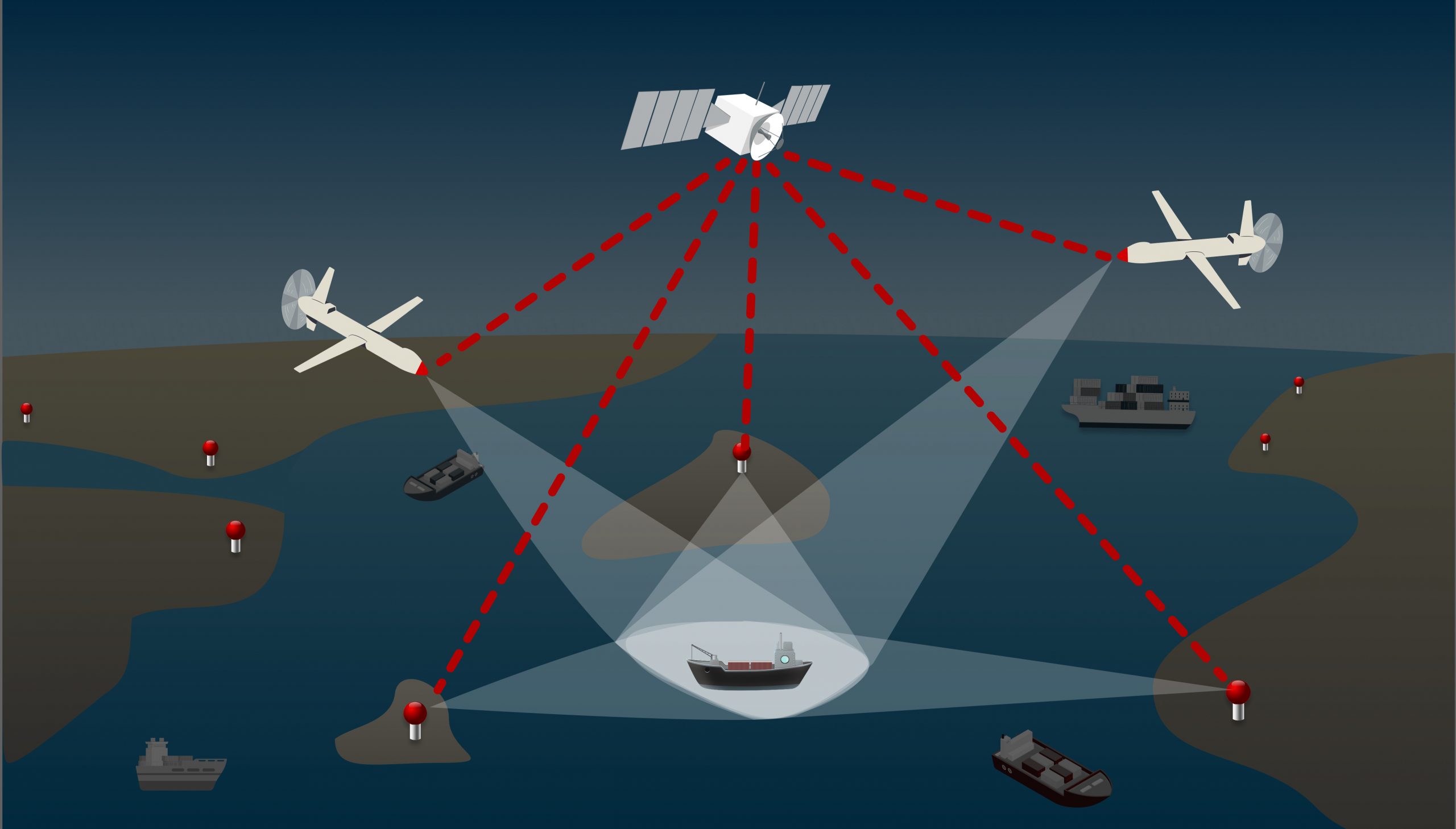
The global markets for maritime security, GNSS integrity, and the detection of uncooperative ‘dark ships’ are developing rapidly. This is due to geopolitical tensions, the expansion of offshore infrastructure, and the growing demand for robust monitoring capabilities.
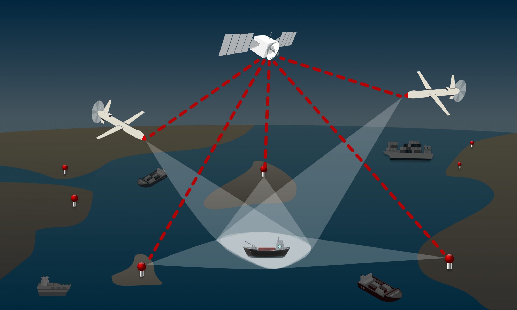
BlueSentinel is an innovative, space-enabled maritime surveillance system designed to detect and track vessels, even in the most remote and infrastructure-poor regions. It builds on proven land-based tracking technology by integrating satellite timing and communication.
The system passively detects radar signals, AIS/VDES transmissions, and GNSS anomalies, and can also identify spoofing, jamming, and dark vessel activity. Its compact sensors can be deployed on drones, autonomous buoys or coastal installations, operating independently of local networks. This makes BlueSentinel ideal for enhancing maritime safety, protecting critical offshore infrastructure, and supporting environmental enforcement in inland waters, the Arctic, and beyond.
Benefits:
Real-time anomaly detection with the ability to alert, escalate or trigger satellite-based follow-up actions.
Operational resilience for maritime sector through GNSS-independent tracking (infrastructure-based sensors) and low timing requirements (achievable with RTC modules).
Extending coverage to the most challenging environments (e.g. offshore zones, Arctic regions, remote coastlines).
Seamless integration with existing systems (VTS, Coastal Surveillance, Defence Platforms).
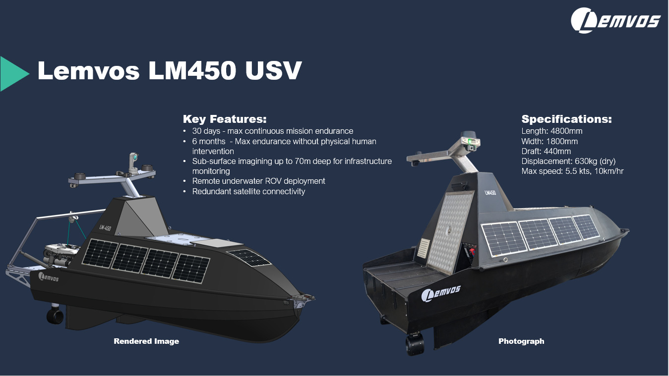
Due to their critical nature, the monitoring of subsea cables and pipelines has become a matter of national interest. Historically, these infrastructures have largely been unmonitored. However, recent acts of sabotage have prompted governments to consider ways of monitoring and protecting these vital assets.
Lemvos has developed an automated, GNSS-guided, satellite-connected Unmanned Surface Vessel (USV) for monitoring subsea infrastructure. Equipped with high-resolution sonar imaging, the system enables 100% remote monitoring in harbour and offshore environments. This technology plays a crucial role in securing valuable subsea assets of national importance, such as cables and pipelines, by providing reliable, continuous surveillance.
Benefits:
Ability to increase efficiency, scalability and cost savings for subsea monitoring, while reducing environmental impact and safety risks.
With semi-autonomous capabilities, a single operator can manage multiple USVs simultaneously, significantly expanding coverage compared to traditional crewed vessels.
Remote operation eliminates travel time and the DockMaster system automates deployment, reducing downtime and maximising productivity.
Fuel and CO₂ emissions are significantly reduced due to the compact, crew-free design of the vessel.
This platform allows businesses and public bodies to deliver targeted, contextualised health interventions without the need for extensive manual monitoring. Using data from the EU Copernicus program for Earth Observation, the solution includes tools for air quality monitoring, workspace optimisation, heat stress management and predictive health analytics to proactively protect the workforce, ensure regulatory compliance and improve productivity and well-being.
For businesses, particularly in occupational health, the technology provides a detailed understanding of workplace health dynamics. It identifies health risks and implements tailored interventions to improve health outcomes, productivity, absenteeism and employee satisfaction.
Public bodies benefit from precise targeting of interventions, improved resource allocation and rapid response to health threats. This approach minimises the impact of environmental hazards and ensures relevant interventions, leading to a resilient public health infrastructure, improved community wellbeing and reduced healthcare costs.
Benefits:
Proactive workforce protection, increased employee satisfaction and reduced absenteeism
Detailed understanding of workplace health dynamics
Identification of health risks and tailored occupational health interventions
Over millennia, animals have adapted their behaviour to Earth’s unique range of ecosystems and developed advanced senses and instincts as a result. By tracking animal movements and activity patterns through a constellation of satellites, TALOS aims to provide insights into animal behaviour to complement Earth observation data for various markets.
The solution includes multiple cubesats with IoT payloads connected to lightweight tags attached to a variety of animals. The collected data includes location, altitude, acceleration, temperature, humidity and barometric pressure, providing valuable information with broad applications for understanding the impacts of climate change, tracking biodiversity loss and detecting animal and zoonotic diseases.
Developed and tested as part of the Max Planck Institute’s ICARUS initiative, the project aims to refine the payload technology for compatibility with even smaller cubesats to turn the successful research surrounding the ICARUS initiative into a viable commercial product.
Benefits:
Monitoring animal movements and migration patterns from space
Bi-directional communication between low-Earth orbit cubesats and miniature, lightweight animal tags
Insight into the effects of climate change, tracking of biodiversity loss and detection of animal and zoonotic diseases
Applications for wildlife tracking, livestock monitoring, weather information technologies and wildfire detection
Biodiversity Monitoring with Satellites and IoT Sensors
Hula Earth helps companies comply with upcoming EU biodiversity regulations (CSRD and EU Taxonomy) by quantifying the impact of their business activities on biodiversity. Current compliance is hampered by the inability to accurately monitor and assess these impacts. Hula’s solution facilitates impact assessments across supply chains and infrastructure projects, in line with evolving standards, using satellite imagery and proprietary sensor network data.
By combining data from satellites and locally deployed IoT sensors, the solution quantifies both positive and negative environmental changes through a scalable and cost-effective approach. It provides insights into climate resilience, vegetation vigour and biodiversity values, enabling organisations to confidently navigate regulatory requirements.
By committing to sustainability and biodiversity conservation, companies can gain better and more cost-effective access to capital, ensuring compliance and unlocking opportunities for improved financial performance and investment access.
Benefits:
Blended approach integrating satellite and proprietary data from IoT sensor network
Enables companies to reliably demonstrate positive biodiversity impacts
Ensures compliance with upcoming EU biodiversity regulations
Enables eligibility for cost-effective access to capital